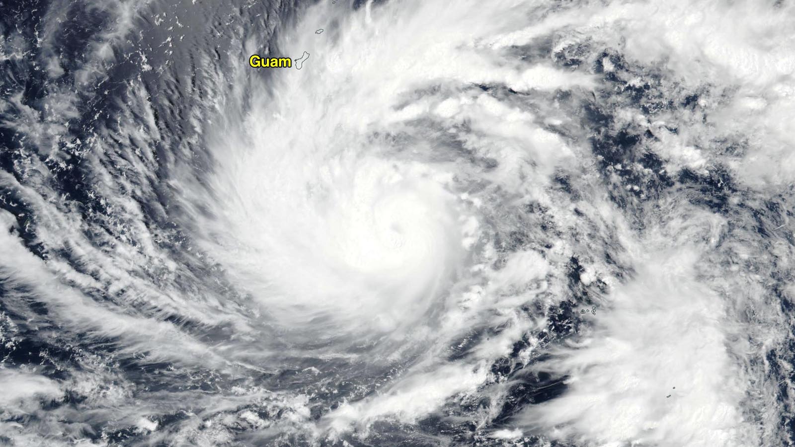
Typhoon warning flags are flying for Guam and Rota in the U.S. Northern Mariana Islands, and a Tropical Storm Warning is up for the islands of Tinian and Saipan, as Typhoon Mawar heads north-northwest at 6 mph toward an expected landfall Wednesday local time (Tuesday evening U.S. EDT). Guam radar showed the outer bands of Mawar were already affecting the islands, which were under a Flash Flood Watch.
Mawar, meaning “rose” in Malaysian, has steadily intensified over the past two days; the 12Z Monday (8 a.m. EDT) advisory from the Joint Typhoon Warning Center put Mawar’s winds at 105 mph, up from 80 mph 24 hours previous to that. The Japan Meteorological Agency, the official agency responsible for typhoon warnings in the Northwest Pacific, estimated that Mawar had top winds of 85 mph (10-minute average) and a central pressure of 970 mb at 12Z Monday.
Forecast for Mawar
At 8:56 p.m. local time Monday, the National Weather Service in Guam was forecasting that Mawar would make landfall on Wednesday local time, bringing sustained winds of 120 mph, gusting to 140 mph. A storm surge of four to six feet was predicted, potentially reaching eight feet in the northern eyewall. Torrential rains of eight to 15 inches, with locally higher amounts were predicted, and dangerous high surf of 15-25 feet was predicted to affect Guam Tuesday through Wednesday.
Mawar has favorable conditions for intensification, with moderate wind shear of 10 knots and warm sea surface temperatures of 29-30 Celsius (84-86°F). Satellite loops show that Mawar has grown increasingly well-organized, though a prominent eye was not yet apparent. Warm waters extend to great depth along Mawar’s track, giving it plenty of heat energy to draw upon for intensification. The Joint Typhoon Warning Center is predicting that Mawar will intensify to a category 3 typhoon with 120 mph winds by the time it reaches Guam, with continued intensification to a category 4 storm with 145 mph winds by Friday. The Japan Meteorological Agency predicts that Mawar will peak with a central pressure of 915 mph on Thursday and Friday, which would put it near category 5 strength. The 6Z Monday run of the HWRF model had Mawar as a category 4 storm with 145 mph winds and a central pressure of 928 mb on Friday.
It is too soon to speculate on what threat Mawar may pose to any land areas after it clears the Northern Mariana Islands, but any such threat would most likely be about a week away. If the typhoon moves north of about 22 degrees north latitude (roughly parallel with Taiwan), the storm will encounter water temperatures below 26 degrees Celsius (79°F), which would cause substantial weakening.
Mawar is the second named storm of the 2023 typhoon season; the other was Tropical Storm Sanvu, a short-lived system that affected open ocean areas well to the east-southeast of Guam April 20-21. According to the Colorado State University real-time tropical cyclone statistics page, the Northwest Pacific typically has 2.5 named storms and 1.2 typhoons by May 22, so the 2023 season is close to average in those respects.

Guam typhoon history
Guam and the Northern Mariana Islands are no strangers to typhoons. According to the NOAA historical hurricane tracks website, during the 50-year period 1972-2021, no fewer than 66 typhoons of category 1 or higher strength passed within 50 miles of the islands. However, only six of these have occurred before June 1; four of these were of category 3 or higher strength. Thus, Typhoon Mawar is an unusually early typhoon for the islands. The most recent of these early-season typhoons was Typhoon Dolphin, which passed between Guam and Rota as a strengthening category 2 storm with 110 mph winds on May 15, 2015. Dolphin later intensified into a category 5 storm with 160 mph winds, one of 20 typhoons to have achieved category 5 strength before June 1.
The Northern Mariana Islands have gotten a pass from any tropical storms or typhoons over the past three years (2020-2022). Those years have been La Niña years, which are typically quiet for tropical cyclone activity on the eastern side of the Northwest Pacific basin, where these islands lie. During La Niña years, the Pacific’s warmest waters are farther to the west, and the monsoon trough that spawns much of the basin’s tropical cyclones lies closer to the Asian coast. This keeps most tropical cyclones away from the Northern Mariana Islands. The last typhoons to pass through the islands occurred in 2019, when category 5 Hagabis and category 4 Bualoi passed near Anatahan Island, about 250 miles north of Guam.
According to EM-DAT, the international disasters database, the strongest and most destructive typhoon to hit Guam was Typhoon Karen of 1962, which hit the island Nov. 11 as a category 5 storm with 170 mph winds, killing six and doing $2.4 billion in damage (2022 dollars). Guam’s deadliest typhoon was Pamela of 1976, which hit Guam May 21 as a category 4 storm with 140 mph winds, killing nine and doing over $600 million in damage.
Tropical Storm Risk (TSR) predicts an active typhoon season
TSR (tropicalstormrisk.com) issued its first seasonal typhoon forecast on May 5 and called for an above-average typhoon season: 29 named storms, 19 typhoons, 13 major typhoons, and an accumulated cyclone energy, or ACE, index of 394 (31% above average). The 30-year averages (1991-2020) are 26 named storms, 16 typhoons, and 9 major typhoons. TSR gave a 60% chance the 2023 season would be in the top one-third of years for activity, a 31% chance of being in the middle third, and only a 9% chance of ranking in the lowest one-third.
Quiet in the Atlantic
In the Atlantic, the National Hurricane Center is monitoring an area of low pressure a few hundred miles southwest of Bermuda. The low is expected to move to the northeast over the next few days and bring some heavy rain showers to Bermuda, but development into a tropical cyclone is not expected. In their 8 a.m. EDT Monday Tropical Weather Outlook, the disturbance was given just 10% odds of development. NOAA issues their first 2023 Atlantic hurricane season forecast on Thursday, May 25.
Storm chasers Jim Edds and James Reynolds are on Guam and will be documenting the impact of Mawar on the island via their Twitter feeds.
Bob Henson contributed to this post.
Website visitors can comment on “Eye on the Storm” posts (see comments policy below). Sign up to receive notices of new postings here.
Source link