A large area of low pressure, designated Invest 98L by the National Hurricane Center, is developing north of the Dominican Republic and Puerto Rico. This low will gradually grow more organized this week and is likely to become a named tropical or subtropical storm that will affect the Bahamas and Florida on Tuesday through Thursday. Beginning on Tuesday, Florida’s Atlantic coast will experience widespread minor to moderate coastal flooding, beach erosion, gusty squalls, and the potential for heavy rain. The system’s large size and non-tropical origin will make rapid intensification unlikely. However, 98L could hit Florida as a strong tropical or subtropical storm, and a category 1 hurricane cannot be ruled out. Late in the week, 98L is expected to move to the north and bring heavy rains to much of the Southeast U.S. coast.
An unusual storm for November
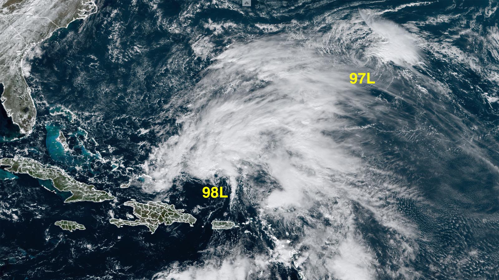
98L originated as an upper-level low pressure system that cut off from the jet stream to the north and drifted southwards into the Bahamas. Satellite images on Sunday showed the broad low had a large amount of heavy thunderstorms that were growing more organized, and the system was beginning to resemble a subtropical storm. An infusion of tropical moisture from the Caribbean, combined with very warm ocean waters of 28.5 degrees Celsius (83°F) – about 1 degree Celsius (1.8°F) above average – will combine to give 98L a more tropical appearance by Monday, though.
The moist flow of air from the south that is feeding into 98L brought heavy rains to the Dominican Republic on Friday, when heavy rains of 4-8 inches (100-200 mm) fell near the capital, Santo Domingo, bringing heavy street flooding. Heavy rains of 4-8 inches also affected much of Puerto Rico Friday through Saturday. A Flood Watch is posted for the island through Monday.


Forecast for 98L
November is an unusual time to see a tropical storm form in this region, since wind shear from the strong upper-level winds of the polar jet stream and subtropical jet stream are usually high. However, an unusually strong ridge of high pressure has settled in over the eastern U.S., bringing a pocket of unusually low wind shear over the Bahamas. The clockwise flow of air associated with the high will impart a westerly motion to 98L, likely resulting in a landfall along the east coast of Florida between Wednesday afternoon and Thursday afternoon.
An east-to-west track into Florida for a tropical or subtropical storm in November is very unusual, and has only occurred once on record, during the Yankee Hurricane of 1935, which made landfall in northern Miami Beach as a category 2 hurricane with 100 mph winds on November 4. Since 1980, six tropical cyclones – four tropical storms and two tropical depressions – have struck the Florida peninsula in November, all initially from the south or west, and none with maximum sustained winds over 65 mph.
As 98L heads west toward Florida on Tuesday and Wednesday, it will encounter moderate to high wind shear of 15-25 knots as strong upper-level winds out of the southwest affect the storm. 98L will also be entering a region of increasingly dry air, and these two influences are likely to prevent rapid intensification of the storm.


After 98L hits Florida, a trough of low pressure passing to the north is expected to turn the storm to the north and north-northeast, resulting in a track along or just inland along the Southeast U.S. coast. The 6Z Sunday run of the GFS model, which showed a borderline tropical storm/category 1 hurricane hitting Florida on Thursday morning, predicted that 98L would bring a swath of 3-6 inches of rain along its path across Florida and northwards into the Southeast U.S.; the 6Z Sunday run of the European model, which predicted landfall in Florida on Thursday morning as broad, low-end subtropical or tropical storm with 40 mph winds, predicted lesser rainfall amounts of 2-4 inches. In recent runs, the European model has been steadily correcting toward the stronger GFS predictions, making it more likely that 98L will be at least a moderate-strength tropical or subtropical storm with 50 mph winds on Wednesday as it approaches Florida.
In their 7 a.m. EST Sunday Tropical Weather Outlook, the National Hurricane Center gave 98L 2-day and 5-day odds of development of 70% and 90%, respectively. The next name on the Atlantic list of storms is Nicole. The first hurricane hunter mission into 98L is scheduled for Monday morning.
The king tides are coming this week
The arrival of the full moon on Tuesday will bring some of the highest tides of the year – the king tides. During the time of high tide through Wednesday, onshore flow in advance of 98L is likely to drive minor to moderate coastal flooding at many locations along the Southeast U.S. coast. The high tides between 7-9 a.m. EST Monday, Tuesday, and Wednesday will be particularly elevated from the king tides, and the odds of coastal flooding will be increased at those times.
NOAA is predicting that a storm surge of 3-3.5 feet could affect the northeastern Florida coast at Fernandina on Wednesday, during both the morning and evening high tides. A storm surge of 2-2.5 feet and moderate coastal flooding are predicted at Charleston, SC, during the morning high tides on Tuesday and Wednesday.
Tiny but tenacious, disturbance 97L may yet develop
The unseasonably strong upper ridge that will steer 98L toward Florida has also given a much more modest system, which was designated Invest 97L on Saturday, a chance to develop. A small circulation center was left behind this weekend at the tail end of the strong, non-tropical storm system that swept Hurricane Martin into its orbit.
Like Martin and 98L, 97L is benefitting from the exceptionally warm waters for so late in the season that prevail across much of the northwest Atlantic. Sea surface temperatures (SSTs) at this latitude – poleward of 30 degrees north – are running around 26 degrees Celsius (79°F), right at the usual threshold for tropical development and more than 1 degree Celsius (1.8°F) above average. However, westerlies at the jet-stream level are shrieking above 97L, bringing over 50 knots of wind shear. This shear is pushing convection well east of the center as soon as it forms, and leaving the center a naked swirl. Moreover, the atmosphere surrounding 97L is quite dry, with a mid-level relative humidity around 45 percent.
Because convection has been regenerating near 97’s center off and on, there remains a chance that a tropical or subtropical cyclone could develop in the next day or two. NHC gives 97L a 70% chance of developing into at least a depression in the next two days, perhaps as soon as Sunday afternoon; these odds may be generous. The 06Z Sunday runs of the HMON and HWRF intensity models suggest that 97L’s best chance to intensify might be late Monday or Tuesday, before the system moves northeastward over colder waters and interacts with another midlatitude storm.
Website visitors can comment on “Eye on the Storm” posts (see comments policy below). Sign up to receive notices of new postings here.
Source link