September 2022 was Earth’s fifth-warmest September since record-keeping began in 1880, NOAA’s National Centers for Environmental Information (NCEI) reported October 14. NASA rated September as the fourth-warmest on record, behind 2016, 1.15 degrees Celsius (2.07°F) above the 1880-1920 period – its best estimate for when preindustrial temperatures last occurred. The European Copernicus Climate Change Service rated September 2022 as the fourth-warmest September on record; the Japan Meteorological Agency rated it the sixth-warmest. Such minor differences in the agencies’ rankings can result from the different ways they treat data-sparse regions such as the Arctic; the top six warmest Septembers in the NOAA database differ by only 0.06°C.
Land areas had their seventh-warmest September on record in 2022, with global ocean temperatures the fourth-warmest on record, according to NOAA. North America had its warmest September on record; Asia, its fifth-warmest; and Africa, its sixth-warmest. Oceania, Europe, and South America each had a warmer-than-average September, but the month did not rank among their top 10 on record.
In the U.S., it was the fifth-warmest September on record, with Utah and Nevada reporting their warmest September on record. Ten other western states reported a top-10 warmest September on record. The month capped off what now ranks as the warmest four-month period in contiguous U.S. history: June-September 2022 (average temperature 72.47°F), as noted by Guy Walton (@climateguyw) and confirmed by Maximiliano Herrera (@extremetemps).
In addition, September was very dry in the central U.S., with a top-10 driest September on record in five central U.S. states contributing to the lowest water levels in 10 years on the Mississippi River. These low levels were interfering with exports of U.S. grain during the peak of the harvest season, and allowing salt water to intrude into the drinking water supply in southeastern Louisiana.


The year-to-date global surface temperature is the sixth-highest on record, and the year 2022 is virtually certain to rank among the 10 warmest years on record, according to NOAA. However, it is less that 5% likely to rank in the top five, and there is less than a 0.1% chance that 2022 will rank as the warmest year on record, largely because La Niña conditions very likely will prevail for the rest of the year (more below).


Fifteen billion-dollar U.S. weather disasters in 2022
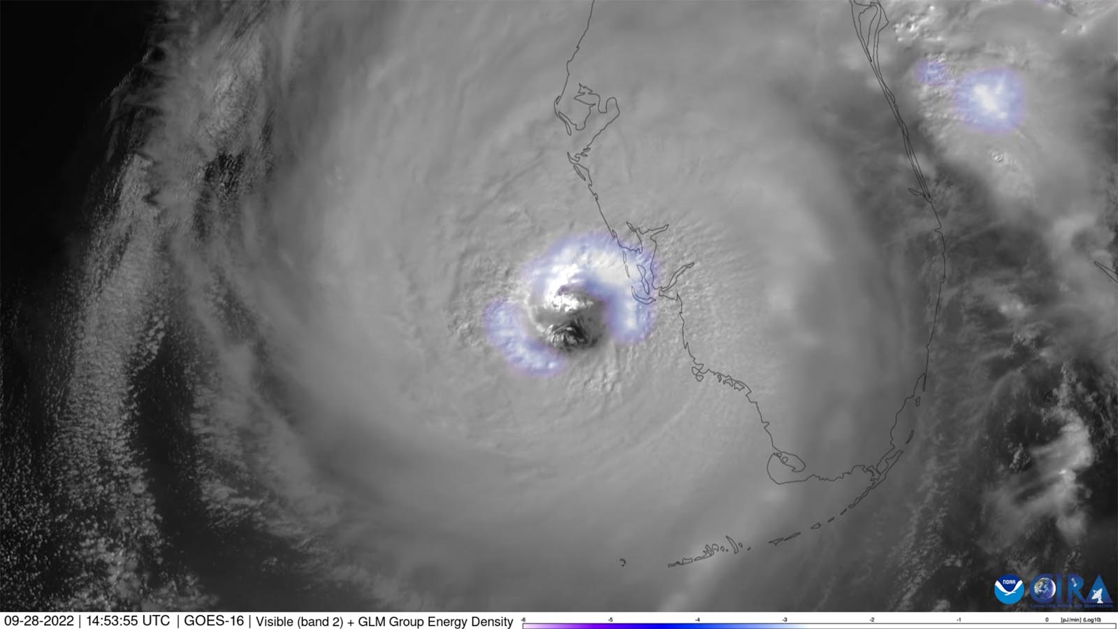
The U.S. suffered two billion-dollar weather disasters in September: Hurricane Fiona in Puerto Rico, and Hurricane Ian in Florida and South Carolina, bringing to 15 the number of such disasters so far in 2022, according to NOAA. The 1980 – 2021 inflation-adjusted average for an entire year is 7.7 billion-dollar weather events; for 2017 – 2021, the average was 17.8 events. This year is the record eighth-consecutive year in which the U.S. experienced 10 or more billion-dollar weather disasters.
The billion-dollar U.S. weather events of 2022 included 1 drought event, 1 flooding event, 10 severe storm events, 2 tropical cyclone events, and 1 wildfire event. Overall, these events resulted in the deaths of 342 people and had significant economic effects on the areas impacted. NOAA said damage from Hurricane Ian would likely exceed $50 billion, which would make it a top-10 most expensive weather disaster in U.S. (and world) history.
At least one other billion-dollar weather disaster outside the U.S. occurred in September: Typhoon Hinnamnor, which made landfall in South Korea on September 5 as a category 2 storm with 100 mph winds, killing 11 and causing over $1.2 billion in damage.
One of the worst weather disasters of 2022 continued to unfold in September in Nigeria, where months-long heavy rains have killed 500 people, displaced 1.4 million, and destroyed more than 45,000 homes.
An unusually long La Niña continues
La Niña conditions continued during September and are expected to persist through the Northern Hemisphere autumn and winter (75% chance during December – February). Thereafter, a transition to neutral conditions is predicted (a 54% chance on neutral conditions in February – April 2023), NOAA reported in its October monthly discussion of the state of the El Niño/Southern Oscillation, or ENSO. The odds of El Niño conditions are no more than 15% through the Northern Hemisphere spring of 2023, increasing to 26% for the May – July period.
Over the past month, sea-surface temperatures in the benchmark Niño 3.4 region of the eastern tropical Pacific (5°N-5°S, 170°W-120°W) were 0.7 – 0.9 degree Celsius below average, as analyzed at tropicaltidbits.com. The range for “weak” La Niña conditions is 0.5-1.0 degree Celsius below average; the range for “moderate” La Niña conditions is 1.0-1.5 degrees Celsius below average.
A third consecutive northern winter with La Niña in 2022-23 would be unusual but not unprecedented: Three-year La Niña sequences occurred in 1973-76 and 1998-2001. There have been no four-year La Niña sequences in NOAA data extending back to 1950, although La Niña was present in five out of six northern winters from 1970 to 1976.


The impact of the current La Niña event may be boosted by a negative Pacific Decadal Oscillation, or PDO. The PDO is an index of sea-surface temperatures across the northeast and tropical Pacific Ocean that reflects some of the circulation aspects of the El Niño-Southern Oscillation. The PDO can swing sharply from month-to-month, but usually it leans positive (warm) or negative (cool) for a few years at a time. Nearly every month since 2017 has had a negative PDO; September’s value was the lowest for any September since 2012, and the eighth-lowest September value in NOAA data going back to 1854. When the PDO is negative, La Niña’s impacts often are more pronounced.
Arctic sea ice: 11th-lowest September extent on record
Arctic sea ice extent during September 2022 was the 11th-lowest in the 44-year satellite record, and had the highest September extent since 2014, according to the National Snow and Ice Data Center, NSIDC. The annual sea ice minimum occurred on September 18, and was the 10th-lowest minimum on record, tied with 2018 and 2017. Ice-free navigation was possible during September through Canada’s Northwest Passage, and through the Northern Sea Route along the north coast of Russia.
Antarctic sea ice extent in September was the fifth-lowest on record for September. Antarctic sea ice extent tended to increase slightly from the 1980s through the 2010s, but it has decreased notably from 2017 onward, whereas arctic sea ice extent has decreased more consistently and dramatically over the past 40 years.
As of September 12, Greenland had a near-average melt year overall, with the total melt-day area ranking twentieth in the 44-year record. However, a late-season heat wave and melt event, unprecedented in the historical record, occurred in Greenland from September 2 to 5.
Notable global heat and cold marks for September 2022
The information below is courtesy of Maximiliano Herrera. Follow him on Twitter: @extremetemps.
– Hottest September temperature in the Northern Hemisphere: 51.8°C (125.2°F) at Death Valley, California (USA), September 6;
– Coldest September temperature in the Northern Hemisphere: -35.8°C (-32.4°F) at Summit, Greenland, September 25;
– Hottest September temperature in the Southern Hemisphere: 44.3°C (111.7°F) at Villamontes, Bolivia, September 8;
– Coldest September temperature in the Southern Hemisphere: -80.7°C (-113.3°F) at Dome Fuji, Antarctica, September 3;
– Highest 2022 average temperature to date (Jan.-Aug.) in the Southern Hemisphere: 29.4°C (84.9°F) at Surabya AP, Indonesia; and
– Highest 2022 average temperature to date (Jan.-Aug.) in the Northern Hemisphere: 31.9°C (89.4°F) at Matam, Sengal.
Major weather stations in September: 15 all-time heat records
Among global stations with a record of at least 40 years, 15 set (not just tied) an all-time heat record in September:
Rasht (Iran) max. 39.4°C, September 4;
Santo Domingo (Dominican Republic) max. 37.7°C, September 5;
Fairfield (California,USA) max. 47.2°C, September 5;
Livermore (California,USA) max. 46.7°C, September 5;
Sacramento (California,USA) max. 46.7°C, September 6;
Ukiah (California,USA) max. 47.2°C, September 6;
Merced (California,USA) max. 46.1°C, September 6;
Napa (California,USA) max. 46.1°C, September 6;
Santa Rosa (California, USA) max. 45.6°C, September 6;
San Jose AP (California, USA) max. 42.8°C, September 6;
King City (California, USA) max. 46.7°C, September 6;
Calistoga (California, USA) max. 47.8°C, September 6;
Kamiichi (Japan) max. 37.4°C, September 6;
Canefield (Dominica) max. 36.3°C, September 12: New national record high for Dominica; and
Balsas (Brazil) max. 41.1°C, September 12.
Nine all-time national/territorial heat records set or tied in 2022
One nation set or tied an all-time reliably measured national heat record in September (Dominica), bringing the total of such records to nine in 2022 (plus one, if considering that Taiwan beat their all-time heat record in two separate months):
Paraguay: 45.6°C (114.1°F) at Sombrero Hovy, January 1;
Australia: 50.7°C (123.3°F) at Onslow AP, January 13 (tie);
Uruguay: 44.0°C (111.2°F) at Florida, January 14 (tie);
Vatican City: 40.8°C (105.4°F), June 28;
United Kingdom: 40.3°C (104.5°F) at Coningsby, July 19;
Jersey (UK dependency): 37.9°C (100.2°F) at Mason St. Louis, July 18;
Taiwan: 41.4°C (106.5°F) at Zhuoxi, July 22; beaten on August 21, with 41.6°C at Fuyuan;
Hong Kong: 39.0°C (102.2°F) at Sheng Shui, July 24 (tie); and
Dominica: 36.3°C (97.3°F) at Canefield, September 12.
In addition, all-time heat records were set in July for all three of the Great Britain countries that are part of the United Kingdom:
England: 40.3 °C (104.5 °F) at Coningsby, July 19
Wales: 37.1 °C (98.8 °F) at Hawarden, July 18
Scotland: 34.8 °C (94.6 °F) at Charterhall, July 19
Two all-time national/territorial cold records set or tied in 2022
As of the end of September, two nations or territories had set or tied an all-time national cold record:
Montenegro: -33.4°C (-28.1°F) at Kosanica, January 25; and
Myanmar: -6.0°C (21.2°F) at Hakha, January 29 (tie).
53 additional monthly national/territorial heat records beaten or tied as of the end of September
In addition to the nine all-time national/territorial records listed above (plus the double record set in Taiwan), 53 nations or territories have set monthly all-time heat records in 2022, for a total of 63 monthly all-time records:
– January (11): Mexico, USA, Croatia, Liechtenstein, Moldova, Comoros, Mayotte, Maldives, Dominica, Equatorial Guinea, Montenegro;
– February (2): Papua New Guinea, Pakistan;
– March (3): Myanmar, Pakistan, Mauritius;
– April (3): British Indian Ocean Territories, Hong Kong, Chad;
– May (6): Chad, Morocco, Liechtenstein, Andorra, Vatican City, Mauritius;
– June (13): Saba, Jersey, Switzerland, Poland, Czech Republic, Japan, Tunisia, Slovenia, Croatia, Turkmenistan, Uzbekistan, Tajikistan, Slovakia;
– July (6): New Caledonia, Andorra, Portugal, Ireland, Denmark, Paraguay;
– August (6): Cocos Islands, Iran, Qatar, Ireland, Saba, Saint Barthélemy; and
– September (3): Georgia, Myanmar, Hong Kong.
Eight additional monthly national/territorial cold records beaten or tied as of the end of September
In addition to the two all-time national/territorial records listed above, eight nations or territories have set monthly all-time cold records in 2022, for a total of 10 monthly all-time records:
– March (2): Montenegro and Cyprus;
– April (2): Andorra, Laos;
– May (2): Vietnam, Thailand;
– July (1): Montenegro; and
– September (1): Greece.
Hemispherical and continental temperature records in 2022
– Highest temperature ever recorded in January in North America: 41.7°C (107.1°F) at Gallinas, Mexico, January 1;
– Highest temperature ever recorded in the Southern Hemisphere (tie) and world record for highest temperature ever recorded in January: 50.7°C (123.3°F) at Onslow AP, Australia, January 13;
– Highest minimum temperature ever recorded in South America: 32.2°C (90.0°F) at Pampa del Infierno, Argentina, January 17; and
– Highest minimum temperature ever recorded in January in the Northern Hemisphere: 29.3°C (84.7°F) at Kenieba, Mali, on January 15 (and again on January 30).
– Highest temperature ever recorded in August in Asia: 53.6°C (128.5°F) at Shush, Iran, on August 9.
Tropical Storm Karl nearing landfall in Mexico
There was little change to the status of Tropical Storm Karl in the southern Gulf of Mexico’s Bay of Campeche on Friday morning, October 14, and the storm is expected to make landfall in Mexico on the south-central coast of the Gulf of Mexico Friday night or early Saturday morning, with heavy rains being the main threat.
At 11 a.m. EDT Friday, Karl was about 140 miles northeast of Coalzacoaltos, Mexico, with top sustained winds of 45 mph. Satellite images showed that the low-level center of Karl was almost exposed to view, with all of the storm’s heavy thunderstorms located to the southeast of the center. This configuration was the result of strong upper-level winds out of the northwest, which were creating a high 20 knots of wind shear over Karl.
Moderate to high wind shear, in combination with a dry surrounding atmosphere, is expected to prevent any significant strengthening of Karl before landfall occurs. Heavy rains of 2 – 5 inches are predicted near the landfall location. Fortunately, the portions of Mexico where Karl’s heaviest rains will be falling have dry soils, with moderate drought in some areas. Karl is predicted to dissipate over Mexico by Saturday night.
A disturbance in the eastern Atlantic to watch
A tropical wave located a few hundred miles south-southwest of the Cabo Verde Islands off the coast of Africa was moving west to west-northwest at about 10 mph on Friday morning. Satellite images showed that the wave was poorly organized, with modest heavy thunderstorm activity with a bit of spin. Conditions were favorable for development, with warm waters near 28 degrees Celsius (82°F), moderate wind shear of 10-20 knots, and a moist atmosphere. The wave has only weak model support for development, and models do not show the wave threatening any land areas in the coming week.
In its 8 a.m. EDT Friday Tropical Weather Outlook, NHC gave the wave 2-day and 5-day odds of development of 10% and 20%, respectively. The next name on the Atlantic list of storms is Lisa.
The authors’ next post on the tropics will be no earlier than Monday.
Bob Henson contributed to this post.
Website visitors can comment on “Eye on the Storm” posts (see comments policy below). Sign up to receive notices of new postings here.
Source link