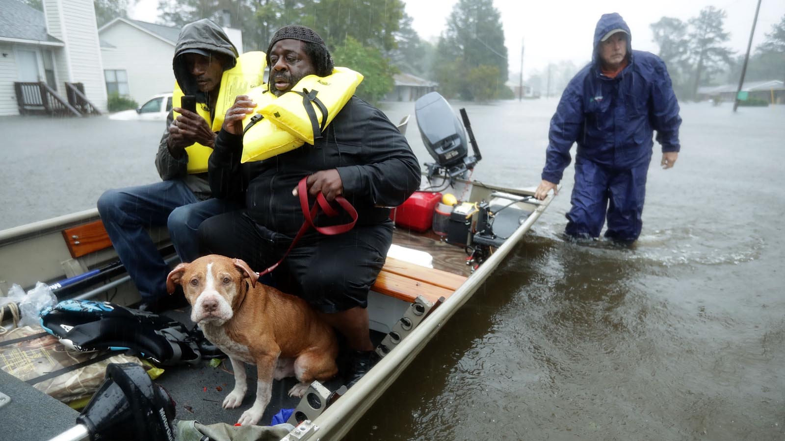
Among the most dangerous extreme weather disasters are thunderstorms and tropical storms, which dump massive amounts of rain over a large geographic area, as opposed to rainfall that’s widespread yet light, or that’s intense yet localized.
Over the past 77 years, the top 11 such extreme events in the contiguous U.S. have all done at least $2 billion in damage, with the top one – Category 4 Hurricane Harvey of 2017, which delivered nearly 25 inches of rain over an area of 50,000 square kilometers over Texas – ranking as the second-costliest weather disaster in world history. Most of Harvey’s $165 billion price tag (2026 USD) resulted from its extreme rains.
Remarkably, six of the top 10 highest-volume U.S. precipitation events occurred over a five-year period (2016-2020), and a seventh one – Hurricane Helene (2024) – has since claimed 11th place (Fig. 1). This suggests that climate change is drastically increasing the odds of extreme rain. Indeed, studies of four of these seven most recent events showed that human-caused climate change made them more likely and/or more extreme.
Six of the seven recent events were very slow-moving tropical systems. A slower-moving tropical cyclone will tend to dump more concentrated rains over small areas, creating an increased flood threat, and there is some evidence from Kossin (2019) and Hall and Kossin (2019) for a slowing of tropical cyclone forward speeds over the continental U.S. and in near-coastal regions over the past century between 1948 and 2017. This change was assessed to be detectable (i.e., not explainable by natural variability alone) with medium confidence by the latest IPCC report. The slowdown can plausibly be linked to climate change, but a 2020 paper emphasized that more research is needed to confidently make this connection.

Many storms that lead to high volumes of rain are hurricanes, but others are not. In fact, out of the top 11 U.S. high-volume precipitation events listed in Fig. 1 above, only five ever reached hurricane strength. The list was originally constructed for the period 1949-2018 by precipitation expert Kenneth Kunkel of the North Carolina Institute for Climate Studies. In an email, he provided an update through 2025 to his list, as reflected in Fig. 1. His ratings were based on four-day rainfall totals over an area of 50,000 square kilometers (an area 40% larger than the state of Maryland). The analysis included only stations that have been reporting reliably throughout the 77-year period, so only a small fraction of current reporting stations were used. However, the use of a consistent network of stations across the entire period increases the reliability of the resulting rankings.
Below is a short description of Kunkel’s top-10 (+1) list of highest-volume contiguous U.S. precipitation events over the past 77 years. We can surmise that the earliest event on the list (the 1962 Columbus Day Storm on the West Coast) was likely not made wetter by climate change, but all of the other events have occurred since 1994 — a time when a significant increase in heavy precipitation events because of climate change was already being observed.

1) Hurricane Harvey, August 27-30, 2017
Hurricane Harvey hit Rockport, Texas, as a Category 4 hurricane with 130 mph winds on August 25, 2017, then stalled just west of Houston for two days, dumping prodigious rains. The storm then drifted out to sea before making another landfall near Beaumont, Texas, dumping catastrophic rains of more than 25 inches in 24 hours. A total rainfall amount in excess of 60 inches was recorded at two locations near Port Arthur, Texas – the heaviest rainfall ever recorded in the U.S. from a tropical cyclone. Harvey dumped more than 30 inches of rain on 6.9 million people; 1.25 million experienced over 45 inches; and 11,000 had over 50 inches, based on seven-day rainfall totals ending August 31.
Harvey caused $165 billion in damage (2026 USD) and killed 89 people. Four studies published in 2017 and 2018 found that human-caused global warming made Harvey’s heavy rains more likely.

2) Hurricane Georges, September 27-30, 1998
Hurricane Georges hit Mississippi on September 28, 1998, as a Category 2 storm with 105 mph (170 km/hr) winds. Georges stalled over southern Mississippi for about 12 hours, then drifted east at 5-10 mph (8-16 km/hr) before finally dissipating near the Florida/Georgia coast three days after making landfall. The slow movement of the storm led to massive rains along the Gulf coasts of Louisiana, Mississippi, Alabama, and the Florida panhandle. Two-day rainfall amounts of 15-30 inches were observed in parts of Alabama, Mississippi, and Florida. Total U.S. damage (including Puerto Rico and the Virgin Islands) was $12 billion (2026 USD); the storm killed four people along the U.S. Gulf Coast.

3) Tropical Storm Imelda, September 17-20, 2019
Tropical Storm Imelda made landfall as a minimal tropical storm with 40 mph winds southwest of Galveston, Texas, on September 17, 2019 – less than two hours after being named. At landfall, Imelda was traveling northward at just 5 mph (8 km/hr), and it maintained a generally northward motion at about that speed for the next 48 hours, gradually weakening.
This very slow pace allowed Imelda to dump rains of 33-44 inches over three days across a large area between Houston and Beaumont, Texas. A peak of 44.29 inches fell near Fannett, Texas, with an extraordinary 31 inches falling in just 12 hours.
Imelda’s rains caused catastrophic flooding that killed five and did over $6 billion (2026 USD) in damage. Numerous vehicles were either stuck or flooded on I-10 between Beaumont and Winnie for over two days. Imelda is yet another of the historically extreme rainfall and flood events that have become a regular occurrence across southeast Texas over the last decade.

4) Northern Louisiana spring storm, March 8-11, 2016
A record-strength upper-level low-pressure system that stalled out over northern Mexico and southern Texas brought rainfall in excess of 20 inches in a four-day period near the Shreveport, Louisiana area, causing historic flooding along the Sabine River basin on the Texas and Louisiana border. More than 1,000 homes and businesses were damaged or destroyed, and the storm killed five people and did $3 billion (2026 USD) in damage.

5) Southern Louisiana tropical disturbance, August 13-16, 2016
Torrential rains of 20-30 inches fell over southern Louisiana August 9-16, 2016, from a tropical depression-like storm that moved slowly across the southern U.S. for a week. Watson, Louisiana, received an astounding 31.39 inches of rain from the event (which was sometimes called “the no-name storm“), and two-day rainfall totals in the hardest hit areas reached the one-in-500-year event threshold.
More than 30,000 people were rescued from the floodwaters that damaged or destroyed over 50,000 homes, 100,000 vehicles, and 20,000 businesses. Thirteen people were killed, and damage was estimated at $14 billion (2026 USD), making it the second most expensive non-hurricane-related flood in U.S. history, behind the summer 1993 flooding in the Midwest. A 2016 attribution study concluded that human-caused climate change had made three-day extreme precipitation events along the central Gulf Coast like this one 1.4 times more likely to occur in 2016 compared to 1900.

6) Columbus Day Storm, October 11-14, 1962
The ‘Big Blow’, as the Columbus Day Storm that hit the Pacific Northwest on October 12, 1962, is nicknamed, is ranked as one of the deadliest and most destructive in western U.S. history. The storm was the rejuvenated extratropical version of Typhoon Freda, which peaked as a Category 3 storm with 115 mph (185 km/hr) winds on October 4.
At least 46 deaths were attributed to the storm in Oregon and Washington, and a further two to eight in California. Most of the deaths were from trees toppled by the winds. Damage was estimated at about $2 billion (2026 USD), and some 53,000 homes were damaged or destroyed. See Chris Burt’s blog for more on the storm.

7) Southeast Texas Upper Low, October 16-19, 1994
High levels of moisture over southern Texas associated with Hurricane Rosa from the Pacific coast of Mexico, combined with low-level moisture from the Gulf of Mexico drawn inland to a warm front by a strong low-pressure system over the southern Rocky Mountains, spawned vigorous thunderstorms that produced torrential rains of eight to 28 inches in five days over southeast Texas. Floods at the one-in-100-year level were equaled or exceeded at 19 of the 43 river gauges in the area. The resulting flooding killed 19 people and caused about $2 billion (2026 USD) in damage.

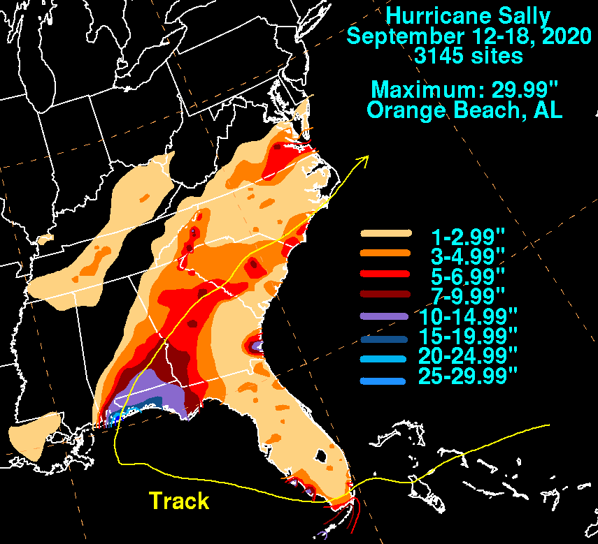
8) Hurricane Sally, September 14-17, 2020
Hurricane Sally made landfall near Gulf Shores, Alabama, on September 16, 2020, as a Category 2 hurricane with maximum sustained winds of 105 mph (170 km/hr) and a central pressure of 965 mb. Sally put on an unexpected last-minute burst of intensification just before landfall, strengthening by 20 mph in just three hours.
During the final 30 hours before landfall, Sally was moving forward at just two to three mph (3-5 km/hr), making for a prolonged wind and storm surge coastal event, and dumping 20-30 inches of rain, causing catastrophic flooding. Sally was responsible for five deaths and over $9 billion (2026 USD) in damage.
Although a specific climate change attribution study has not been done for Hurricane Sally, a 2022 study, “Attribution of 2020 hurricane season extreme rainfall to human-induced climate change,” analyzed the entire 2020 Atlantic hurricane season. It found that climate change increased extreme three-hourly storm rainfall rates by approximately 10% for tropical storm-strength storms and 11% for hurricane-strength storms. Climate change increased extreme three-day accumulated rainfall amounts by approximately 5% for tropical storm-strength storms and 8% for hurricane-strength storms.

9) Hurricane Florence, September 14-17, 2018
Hurricane Florence made landfall at Wrightsville Beach, North Carolina, on September 14, 2018, as a Category 1 hurricane with 90 mph (145 km/hr) winds. Florence slowed to a crawl as it moved inland, bringing record rains and record river flooding to 28 river gauges in the Carolinas. More than 30 inches of rain was recorded at several North Carolina stations, including 35.93 inches at Elizabethtown – an all-time record for the wettest tropical cyclone ever observed north of the Gulf Coast states. Heavy rainfall also occurred in South Carolina, with 23.63 inches observed near Loris – a new state record for rainfall from a tropical cyclone. It took two to three weeks for many river locations to fall below flood stage, with one river cresting a full month after Florence made landfall. At least 53 direct or indirect deaths were blamed on the storm. Climate change made Florence’s rains over North Carolina 5% greater in magnitude according to a 2020 attribution study.

10) West Coast Atmospheric River, February 16-19, 1986
A series of “Pineapple Express” atmospheric river events brought a warm, moist flow of subtropical air originating in the vicinity of Hawaii to the coast of California over a 10-day period (February 11–20, 1986), dumping 30 to 40 inches of rain in some locations. Bucks Lake, at an elevation of 5,750 feet in the northern Sierra Nevada, received 55.72 inches of precipitation, mostly in the form of rain, during the 10-day period. The subsequent flooding was among the region’s worst on record. One of the most infamous events occurred on February 20, when a levee on the Yuba River broke near the towns of Linda and Olivehurst, flooding approximately 30 square miles, forcing the evacuation of 26,000 people, and damaging thousands of homes. Thirteen people died in the floods, and damage was estimated at $1.6 billion (2026 USD).

11) Hurricane Helene, September 25-28, 2024
Hurricane Helene made landfall on September 26, 2024, near Perry, Florida, as a Category 4 storm with 140 mph (225 km/hr) winds. Helene caused up to 15 feet of storm surge along the Florida Big Bend coast and six feet of surge as far south as St. Petersburg. Helene was moving quickly at landfall, then stalled over western North Carolina, where historic rainfall and flooding eclipsed the region’s previous worst flood from 1916. Catastrophic flooding hit Asheville and many surrounding cities; southwestern Virginia and extreme eastern Tennessee were also hit hard. Helene killed 240 people, making it the deadliest Atlantic hurricane since Maria (2017) and the deadliest to strike the U.S. mainland since Katrina (2005). Damage was estimated at $82 billion (2026 USD), making it the seventh-costliest weather disaster in world history.
Researchers at World Weather Attribution determined that Helene’s rainfall was about 10% heavier due to climate change, and the precipitation totals over the two-day and three-day areas of heaviest rainfall were made about 40% and 70% more likely by climate change, respectively.
“If the world continues to burn fossil fuels, causing global warming to reach 2°C above preindustrial levels, devastating rainfall events in both regions will become another 15-25% more likely,” the researchers wrote.
Bob Henson contributed to this post.
![]()
Source link