The Atlantic Ocean was peppered with a peak-season smorgasbord of activity on Wednesday, ranging from a Category 4 Hurricane Fiona – soon to reach Canada with uncommon strength – to a disturbance that has only a number (98L), not yet a name, but with all the earmarks of a system well worth watching as it heads into unusually favorable conditions.
Puerto Rico recovering from an epic deluge
Puerto Rico is in recovery mode after Fiona slammed the island with an average of more than 15 inches of rain, and a peak amount of 34.12 inches (see Tweet below). The rains triggered widespread flash flooding that likely will cost billions, the governor of Puerto Rico said. Only one river gauge remained at flood stage Wednesday afternoon, and Puerto Rico radar revealed only isolated light showers affecting the island.
Virtually the entire island lost power at the storm’s peak, and restoration efforts are still in early stages. The website poweroutage.us estimated on Wednesday morning that power had been restored to about 25% of the 1,468,223 electricity customers it tracks in Puerto Rico. Fiona is being blamed for four deaths in Puerto Rico, one in the Dominican Republic, and one in Guadeloupe.
Fiona expected to pass west of Bermuda
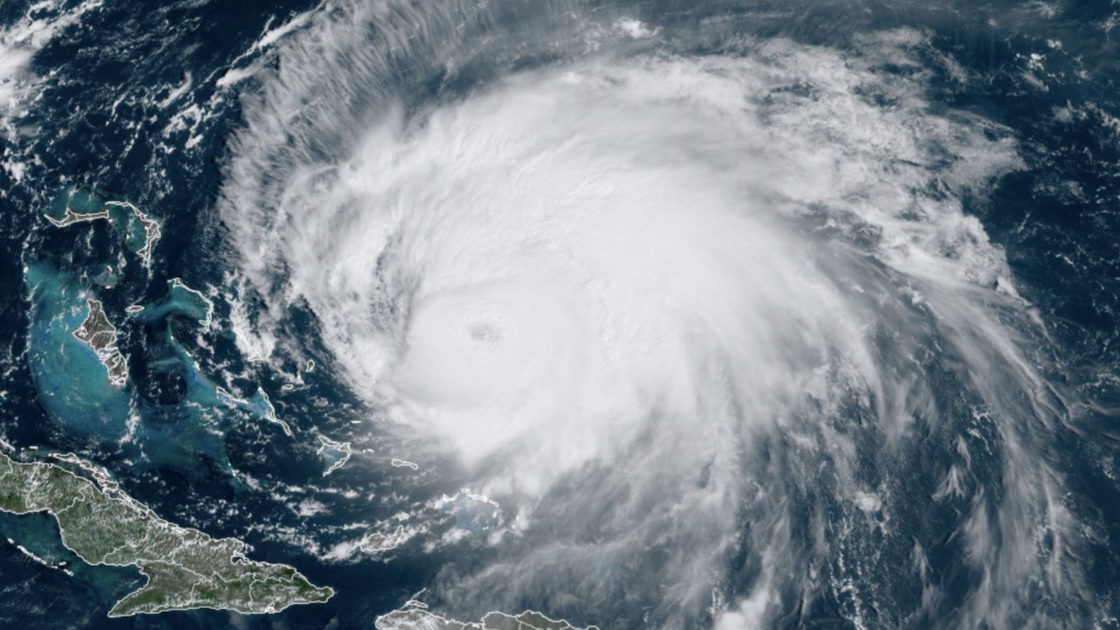
As of 11 a.m. EDT Wednesday, Fiona was centered about 675 miles southwest of Bermuda, moving north at 8 mph. Fiona was a low-end category 4 storm with top sustained winds holding at 130 mph, and conditions are favorable for Fiona to remain a major hurricane for the next two days. Though wind shear of 15-20 knots could be a limiting factor, Fiona will be drawing on very warm sea surface temperatures of 29-30 degrees Celsius (84-86°F), with ample deep oceanic heat content through Wednesday. The National Hurricane Center predicts that Fiona will peak with 140 mph winds on Thursday. Fiona’s wind field will gradually expand, and waves near the center of the hurricane are predicted to reach as high as 42 feet, which will generate large swells and rip currents along parts of the U.S. East Coast over the next several days, and Maritime Canada late in the week.
Fiona is expected to track far enough west of Bermuda to spare the island a direct hit. Nevertheless, Fiona’s gale-force winds will extend to more than 200 miles east of the center on the storm’s stronger right-hand side on Thursday night, when Fiona is expected to pass 50 to 150 miles west of Bermuda. Thus, tropical storm conditions are very likely in Bermuda, but hurricane-force winds are unlikely: The 11 a.m. EDT Wednesday Wind Probability Forecast gave Bermuda an 89% chance of receiving tropical storm-force winds, but only a 13% chance for hurricane-force winds.
Fiona a significant threat to parts of eastern Canada
Fiona is predicted to maintain major hurricane strength unusually far to the north, thanks to sea surface temperatures in the midlatitude waters between Bermuda and Canada up to 2 degrees Celsius (3.6°F) warmer than average. The 11 a.m. EDT Wednesday NHC forecast put Fiona near the eastern tip of Nova Scotia on Saturday morning as an extratropical storm at category 2 strength with sustained 100 mph winds; the Wind Probability Forecast gave eastern Nova Scotia a 32% chance of experiencing hurricane-force winds this weekend.
As Fiona approaches Canada, the hurricane will merge with a trough of low pressure and transition to a hurricane-strength extratropical storm, subjecting Canada to an unusually long and severe battering by what may be one of the strongest storms ever to affect the region. The NOAA/NWS Weather Prediction Center is explicitly forecasting a central pressure below 960 mb near eastern Nova Scotia on Saturday. Such a value would threaten the lowest pressures on record in that region for September. (An all-time record is less likely, since winter storms can be fierce in this area).
The Wednesday morning runs of the GFS and European models are even more eye-opening, predicting that Fiona would reach Nova Scotia and Newfoundland on Saturday morning with a central pressure below 940 mb. According to NOAA, the all-time lowest pressure ever recorded in this region was 940.2 mb on January 21, 1977. The strongest storm classified as a hurricane at landfall in Canada was Ginny (1963), which arrived in Nova Scotia with peak winds of 110 mph.
NHC is predicting 3-6 inches of rain, with isolated amounts up to 10 inches, for Nova Scotia, Prince Edward Island, and western Newfoundland. Rains of this magnitude would cause widespread damaging flooding. Wind damage is also likely to be significant, and with the trees still in full leaf, considerable tree and power line destruction is likely, especially given the breadth of Fiona’s wind field by the time of landfall.
Storm surge will also be a concern in coastal Nova Scotia; the two largest towns at risk are Sydney (population 30,000) and Glace Bay (population 20,000).
Tropical Storm Gaston strengthens in central Atlantic
Tropical Gaston formed on Tuesday in the central North Atlantic, potentially threatening the western Azores on Friday. However, no other land areas are threatened. As of 11 a.m. EDT Wednesday, Gaston had top winds of 65 mph, and was predicted to peak in intensity on Wednesday night with 70 mph winds – just short of hurricane strength. On Thursday, Gaston will be entering a region with higher wind shear and colder waters, and the storm is expected to become post-tropical by Saturday.
Disturbance 98L: potentially dangerous for Caribbean and Gulf of Mexico
A tropical wave designated Invest 98L was bringing gusty winds and heavy showers into the Windward Islands on Wednesday afternoon, as it headed west-northwest at 10-15 mph. This disturbance has the potential to be a strong hurricane in the western Caribbean and/or Gulf of Mexico next week, with the eventual possibility of a U.S. Gulf Coast landfall.
Any development of 98L will be gradual at first. Satellite imagery and Barbados radar on Wednesday afternoon showed 98L with a moderate amount of heavy thunderstorm activity that had changed little in organization since Tuesday. The wave had a good degree of spin, but no well-organized surface circulation.
The main impediment for development for 98L on Wednesday was the presence of Hurricane Fiona so nearby; upper-level outflow from Fiona was bringing strong upper-level winds out of the north-northeast over 98L, creating high wind shear of 20-30 knots. Otherwise, conditions were favorable for development, with warm sea surface temperatures of 30 degrees Celsius (86°F) and a moist atmosphere (mid-level relative humidity of 65%).
Continued high wind shear from Fiona’s upper-level outflow is expected to impede development of 98L through Friday, and 98L’s close proximity to the coast of South America may also hinder it.


Odds for development will rise on Saturday, when Fiona’s upper-level outflow will no longer be affecting 98L. The system will then will be in the central Caribbean, where ideal conditions for development are expected: very warm water (at least 30 degrees C or 86 degrees Fahrenheit) with a high heat content, light to moderate wind shear, excellent outflow channels aloft, and a moist atmosphere (mid-level relative humidity around 70 percent). The entire northern half of the Caribbean has been free of tropical cyclones all season, so these untouched waters (running about 0.5 degrees Celsius or 1 degree Fahrenheit above average for late September) will be particularly ripe for supporting any well-organized cyclone with favorable atmospheric conditions.
The Wednesday morning runs of all three of the top models for tropical cyclone genesis – the GFS, European, and UKMET – showed 98L developing into a tropical depression by early next week at the latest, as did many of the GFS and European model ensemble forecasts.
Over the last couple of days, multiple cycles of the GFS and European operational and ensemble model runs have depicted a robust hurricane moving across the western Caribbean and toward the Gulf of Mexico by the middle of next week. This consensus is a sign of model confidence in favorable conditions and cannot be ignored; however, model unanimity is not the same thing as model skill. Any twist in development along the way could affect all of these model solutions.
It is certainly plausible to anticipate that 98L could turn northwest and enter the Gulf of Mexico next week, as shown in Figure 1, since a trough of low pressure capable of creating the proper steering currents is expected to move across the U.S. Such a track is common toward the later side of hurricane season (late September into October), as the jet stream begins to dip further south and pull tropical systems northward and across the Gulf. Any threat to the U.S. Gulf Coast would most likely be in the general range of 6 to 10 days from now, so there is plenty of time to monitor 98L’s evolution.
In its 2 p.m. EDT Wednesday Tropical Weather Outlook, NHC gave 98L 2-day and 5-days development odds of 70% and 90%, respectively.
Tropical Storm Gaston strengthens in central Atlantic
Tropical Gaston formed on Tuesday in the central North Atlantic, and could pose a threat to the western Azores on Friday, but no other land areas are threatened. As of 11 a.m. EDT Wednesday, Gaston had top winds of 65 mph, and the storm was predicted to peak in intensity on Wednesday night with 70 mph winds – just short of hurricane strength. On Thursday, Gaston will be entering a region with higher wind shear and colder waters, and the storm is expected to become post-tropical by Saturday.
Gaston’s development brings the 2022 Atlantic tally to seven named storms, three hurricanes, and one major hurricane. The 1991-2020 climatological averages for this point in the season are 9.8 named storms, 4.5 hurricanes, and 2.1 major hurricanes. This year’s accumulated cyclone energy (ACE) index is currently running 56% of average for the date, but is catching up toward average, as Fiona churns the Atlantic at major hurricane strength.
Two other waves to watch
A tropical wave expected to move off the west coast of Africa on Thursday has good model support for development this weekend. The wave is expected to move north-northwest between the Cabo Verde Islands and the coast of Africa. In its 2 p.m. EDT Wednesday Tropical Weather Outlook, NHC gave this wave 2-day and 5-day development odds of 30% and 50%, respectively.
A tropical wave in the central Atlantic, several hundred miles west-southwest of the Cabo Verde Islands, was designated Invest 99L by NHC on Wednesday. The wave is in a dry environment (mid-level relative humidity of 50%), but sea surface temperatures are warm and wind shear is light, which favors development. 99L appears well-organized on satellite imagery, and has some limited model support for development as it moves northwest at 5 mph. In its 2 p.m. EDT Wednesday Tropical Weather Outlook, NHC gave 99L 2-day and 5-day development odds of 20% and 30%, respectively.
The next two names on the Atlantic list of storms are Hermine and Ian.
Remembering Vern Dvorak: A legend in hurricane analysis
Eminent meteorologist and hurricane analyst Vernon “Vern” Dvorak died on Monday, September 19, at the age of 100. As much as anyone, Dvorak paved the way for the short-term assessment of changes in hurricane strength made possible by the satellite observing revolution of the 1960s and 1970s, through the development of his pioneering “Dvorak technique” of satellite-based intensity estimates. Even today, there simply aren’t enough reconnaissance aircraft to sample every hurricane or typhoon as thoroughly and often as forecasters would like. Dvorak technique ratings are invaluable in filling this gap.
Based at NOAA’s National Environmental Satellite, Data, and Information Service (NESDIS) for much of his career, Dvorak scrutinized countless images of tropical cyclones in various stages of development, then came up with a decision tree by which a forecaster could rate a cyclone’s strength based on particular geometries in satellite imagery, including spiral bands and evidence of wind shear. Each analyzed cyclone is assigned one of 15 Dvorak ratings (from T1.0 to T8.0, including half-steps). Each rating then relates to a particular wind speed or central pressure, using relationships that differ by formation regions and forecast centers around the world.
Dvorak’s initial work entered the scientific literature though a 1975 paper in Monthly Weather Review, “Tropical Cyclone Intensity Analysis and Forecasting from Satellite Imagery,” with refinements made in subsequent years. An entire line of longwave infrared satellite images is now generated to facilitate the technique, and output from the fully automated Advanced Dvorak Technique is produced at the Cooperative Institute for Meteorological Satellite Studies at the University of Wisconsin-Madison. A 2006 review in the Bulletin of the American Meteorological Society concluded that Dvorak’s work had “fundamentally enhanced the ability to monitor tropical cyclones on a global scale.” Dvorak received a lifetime achievement award in 2002 from the National Weather Association.
A 2016 presentation from NHC hurricane specialist Jack Beven explains the Dvorak technique in depth.
Please donate to help hurricane victims
To help out with Fiona recovery efforts in Puerto Rico, please consider donating to one of these worthy causes:
The Partnership for Inclusive Disaster Strategies (Formerly Portlight.org), helping disabled people in Puerto Rico recover from the hurricane.
The Fiona Community Response Fund, a coalition of community-led organizations working on immediate response to fulfill needs over the short- and long-term.
Website visitors can comment on “Eye on the Storm” posts (see comments policy below). Sign up to receive notices of new postings here.
Source link