

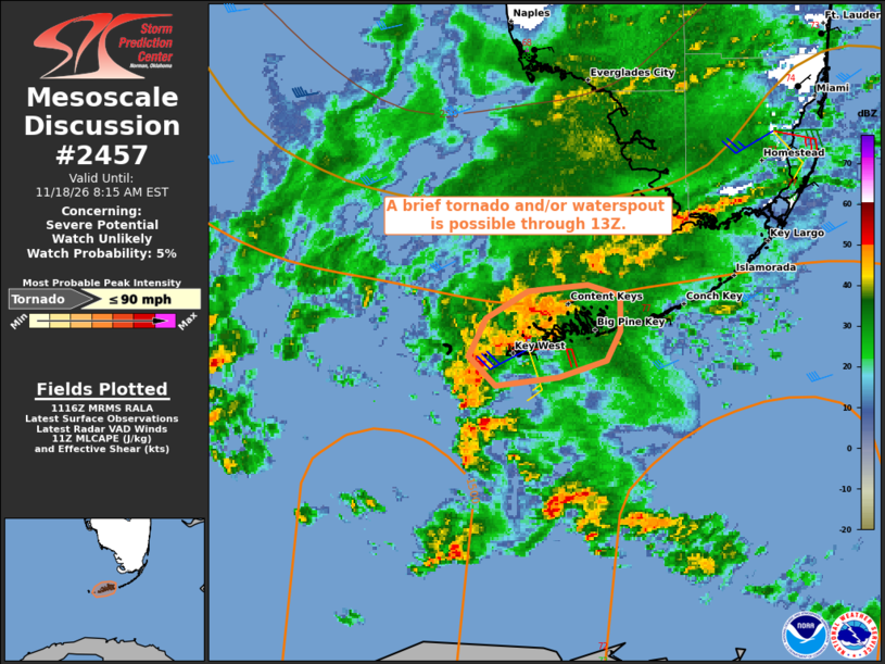
| Mesoscale Discussion 2457 | |
| < Previous MD | |

|
|
   Mesoscale Discussion 2457
   NWS Storm Prediction Center Norman OK
   0519 AM CST Wed Nov 18 2026

   Areas affected...Key West

   Concerning...Severe potential...Watch unlikely

   Valid 181119Z - 181315Z

   Probability of Watch Issuance...5 percent

   SUMMARY...A brief tornado and/or waterspout appears possible through
   13Z. A watch is not anticipated.

   DISCUSSION...Embedded within a broader-scale cyclonic circulation
   slowly drifting southeast toward the area, the Key West (KBYX) radar
   has sampled transient circulations/weak mesocyclones, mainly west
   through north of the radar site over the past hour. The ambient air
   mass is quite moist with boundary-layer dewpoints in the low 70s
   with low LCLs and MLCAPE of around 1000 J/kg, per latest objective
   analysis. Moreover, the current KBYX VWP indicates veering winds
   with height with 35-40 kt of deep-layer shear, and modest 0-3 km SRH
   of 100-150 m2/s2 when modified for observed storm motions.

   Widespread convection and poor lapse rates are expected to limit the
   overall tornado threat. Nonetheless, the very moist environment
   coupled with the modest low-level shear may support the potential
   for a brief tornado and/or waterspout with any deeper, sustained
   storms for the next hour or two.

   ..Mead/Guyer.. 11/18/2026

   ...Please see www.spc.noaa.gov for graphic product...

   ATTN...WFO...KEY...

   LAT...LON   24528128 24438154 24398187 24538200 24728191 24848169
               24878139 24838122 24658121 24528128

   MOST PROBABLE PEAK TORNADO INTENSITY...UP TO 90 MPH
|
|
|
Top/All Mesoscale Discussions/Forecast Products/Home |
|
Source link