

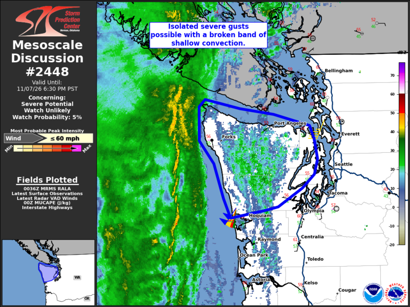
| Mesoscale Discussion 2448 | |
| < Previous MD | |

|
|
   Mesoscale Discussion 2448
   NWS Storm Prediction Center Norman OK
   0637 PM CST Sat Nov 07 2026

   Areas affected...northwestern Washington State

   Concerning...Severe potential...Watch unlikely

   Valid 080037Z - 080230Z

   Probability of Watch Issuance...5 percent

   SUMMARY...A narrow low-topped convective band will move onshore late
   this afternoon and this evening with the potential for isolated
   strong to severe wind gusts. Some isolated risk is possible, but a
   WW is unlikely.

   DISCUSSION...Evening radar imagery showed a narrow forced convective
   band was gradually more organized off the WA coast. Likely tied to
   the surface cold front, strong ascent from an upper trough and
   strong jet streak will approach the coast over the next couple of
   hours. KLGX VAD data and recent RAOB shows that wind fields are
   strengthening ahead of the line with 50-70 kt south/southwesterly
   flow prevalent in the lowest 1-3 km. Despite meager buoyancy (MUCAPE
   100-200 J/kg) and little to no lightning, the strong forcing for
   ascent and moist adiabatic/neutrally stable low-level lapse rates
   will likely be sufficient to maintain the convective band as it
   moves onshore. Convectively enhanced downdrafts may allow for some
   of this strong flow to reach the surface with strong to severe
   gusts, possibly focused in/near the higher terrain.

   More isolated convective cells may eventually develop behind the
   band and move onshore through this evening as much colder
   temperatures aloft steepen low-level lapse rates. Reinforcement of
   the weak buoyancy will develop in the steeper lapse rate
   environment, where perhaps isolated lightning flashes will be
   possible. Still, the weak buoyancy will very likely limit convective
   intensity, and a WW is unlikely.

   ..Lyons/Guyer.. 11/08/2026

   ...Please see www.spc.noaa.gov for graphic product...

   ATTN...WFO...SEW...

   LAT...LON   48352479 48452468 48342403 48262342 48122275 47962268
               47712262 47522267 47362290 47132334 47092355 46982420
               47222433 47662450 47942477 48352479

   MOST PROBABLE PEAK WIND GUST...UP TO 60 MPH
|
|
|
Top/All Mesoscale Discussions/Forecast Products/Home |
|
Source link