

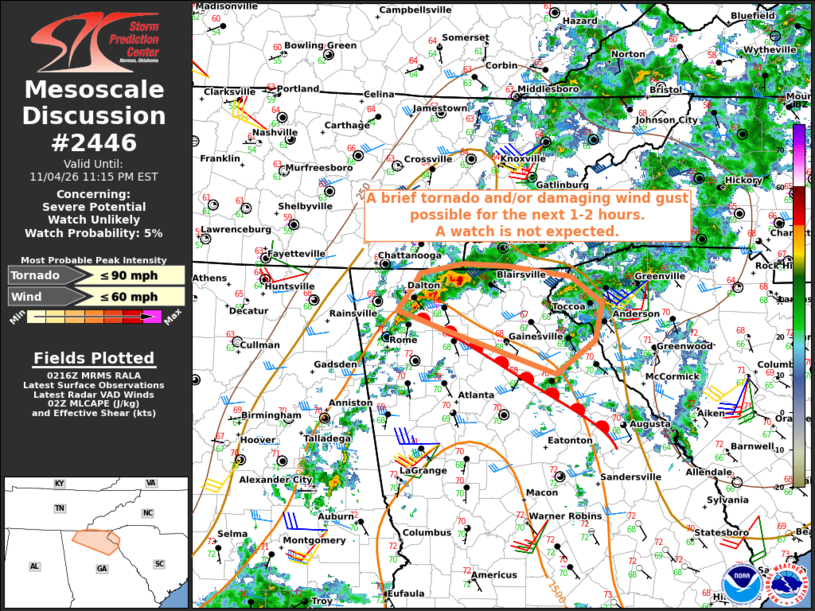
| Mesoscale Discussion 2446 | |
| < Previous MD | |

|
|
   Mesoscale Discussion 2446
   NWS Storm Prediction Center Norman OK
   0819 PM CST Wed Nov 04 2026

   Areas affected...north-central and northeast Georgia into portions
   of far western North Carolina and upstate South Carolina

   Concerning...Severe potential...Watch unlikely

   Valid 050219Z - 050415Z

   Probability of Watch Issuance...5 percent

   SUMMARY...A conditional risk for a brief tornado and/or damaging
   wind gust is expected to persist for the next 1 to 2 hours. Both the
   magnitude and areal extent of the threat are likely to remain too
   small for a watch consideration.

   DISCUSSION...A small cluster of thunderstorms has persisted this
   evening over far north-central GA, in the vicinity of a diffuse
   wedge or warm front with recent intensification noted in volumetric
   radar data. The 00Z FFC sounding is likely somewhat representative
   of the ambient thermodynamic environment, with a moist boundary
   layer and modestly steep midlevel lapse rates contributing to MLCAPE
   of 1000-1500 J/kg. However, a relative warm nose centered around 700
   mb and poor low-level lapse rates are likely hindering parcel
   accelerations to some extent.

   On the condition that storms remain surface-based, a low-probability
   risk for a brief tornado and/or damaging wind gust may persist for
   the next 1 to 2 hours as storms move/develop toward upstate SC,
   where stronger low-level and deep-layer shear exists.

   ..Mead/Guyer.. 11/05/2026

   ...Please see www.spc.noaa.gov for graphic product...

   ATTN...WFO...GSP...MRX...FFC...

   LAT...LON   34608505 34958478 35038432 35018381 34928309 34668274
               34318281 34008326 34438457 34608505

   MOST PROBABLE PEAK TORNADO INTENSITY...UP TO 90 MPH
   MOST PROBABLE PEAK WIND GUST...UP TO 60 MPH
|
|
|
Top/All Mesoscale Discussions/Forecast Products/Home |
|
Source link