

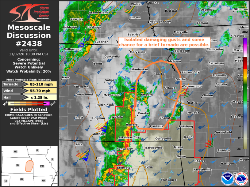
| Mesoscale Discussion 2438 | |
| < Previous MD | |

|
|
   Mesoscale Discussion 2438
   NWS Storm Prediction Center Norman OK
   0834 PM CST Mon Nov 02 2026

   Areas affected...Parts of eastern Kansas

   Concerning...Severe potential...Watch unlikely

   Valid 030234Z - 030430Z

   Probability of Watch Issuance...20 percent

   SUMMARY...Isolated damaging wind gusts and some chance for a brief
   tornado are possible across parts of eastern Kansas this tonight.
   While a watch is not currently expected, storm trends are being
   monitored.

   DISCUSSION...The latest radar data from KICT depicts a
   north/south-oriented line of storms tracking eastward across parts
   of southeastern KS at around 25 kt. Despite a fairly
   coherent/organized cold pool and even some shallow/transient
   circulations embedded in the line, a lack of wind reports suggest
   this activity may be slightly elevated -- given relatively weak
   buoyancy sampled by the TOP 00Z sounding. However, a low-level jet
   will continue strengthening ahead of the line tonight (50 kt flow at
   1 km AGL per INX VWP), which will conditionally support some
   strengthening over the next few hours as it continues across eastern
   KS. Isolated damaging gusts and some chance for a brief tornado
   cannot be ruled out, especially if any mesovorticies evolve.
   Confidence in this scenario is currently low, given recent trends
   and the limited buoyancy, though convective trends are being
   monitored.

   ..Weinman/Gleason.. 11/03/2026

   ...Please see www.spc.noaa.gov for graphic product...

   ATTN...WFO...SGF...EAX...TOP...ICT...

   LAT...LON   37609645 38929632 39299604 39449573 39519535 39429484
               39089460 38689456 37799493 37389530 37409624 37609645

   MOST PROBABLE PEAK TORNADO INTENSITY...85-110 MPH
   MOST PROBABLE PEAK WIND GUST...55-70 MPH
   MOST PROBABLE PEAK HAIL SIZE...UP TO 1.25 IN
|
|
|
Top/All Mesoscale Discussions/Forecast Products/Home |
|
Source link