

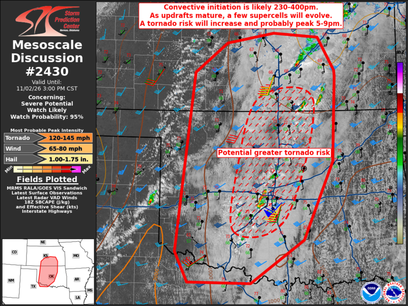
| Mesoscale Discussion 2430 | |
| < Previous MD | |

|
|
   Mesoscale Discussion 2430
   NWS Storm Prediction Center Norman OK
   1255 PM CST Mon Nov 02 2026

   Areas affected...western into central OK...south-central KS...and
   western north TX

   Concerning...Severe potential...Watch likely

   Valid 021855Z - 022100Z

   Probability of Watch Issuance...95 percent

   SUMMARY...Convective initiation is likely 230-400pm over western OK
   along the dryline.  As updrafts mature, a few supercells will evolve
   with an initial large-hail threat.  The tornado risk will increase
   and probably peak 5-9pm as storms approach and move through the
   US-81 and I-35 corridors.

   DISCUSSION...Visible-satellite imagery shows a destabilizing
   stratocumulus field across western OK and more vigorous cumuliform
   development near the dryline and pacific front (located near DDC
   south-southwestward into the eastern TX Panhandle/Caprock vicinity).
   Surface temperatures east of the dryline over northwest TX northward
   through far western OK have risen into the upper 70s deg F with
   additional heating into the 80s expected.  West Texas Mesonet and
   Oklahoma Mesonet dewpoint observations indicate a moist plume
   extending from western north TX northward through western OK into
   the Pratt/Greensburg, KS vicinity.  This warming/destabilizing
   characterization of the boundary layer is in contrast to the airmass
   sampled earlier this morning by the 16 UTC (10am CST) Norman, OK
   raob only depicting very weak buoyancy (100 J/kg MLCAPE) and a 12.4
   g/kg lowest 100-mb mean mixing ratio.

   Expecting additional destabilization with greater mixing and erosion
   of MLCINH to occur over the western 1/3 of OK through the mid
   afternoon.  Forecast soundings show moderate buoyancy (1000-1500
   J/kg MLCAPE) with a moist/high relative humidity boundary layer as
   lowest 100-mb mean mixing ratios increase from 13 to 14-15 g/kg.
   Expecting a few supercells to evolve from the initial discrete
   storms with a large-hail threat ensuing quickly.  The tornado risk
   will likely peak during the 5-9pm period as storms move east through
   the moist plume.  Additional storms will likely develop with a mixed
   mode of supercell and linear segments posing a continued risk for
   tornadoes and severe gusts.

   ..Smith/Bentley.. 11/02/2026

   ...Please see www.spc.noaa.gov for graphic product...

   ATTN...WFO...TSA...TOP...ICT...FWD...OUN...DDC...

   LAT...LON   34439965 37719923 38249849 38439744 38349642 37749605
               37629604 36079612 34649678 33849797 33869936 34439965

   MOST PROBABLE PEAK TORNADO INTENSITY...120-145 MPH
   MOST PROBABLE PEAK WIND GUST...65-80 MPH
   MOST PROBABLE PEAK HAIL SIZE...1.00-1.75 IN
|
|
|
Top/All Mesoscale Discussions/Forecast Products/Home |
|
Source link