

| Mesoscale Discussion 2410 | |
| < Previous MD | |

|
|
   Mesoscale Discussion 2410
   NWS Storm Prediction Center Norman OK
   0348 PM CDT Sun Oct 25 2026

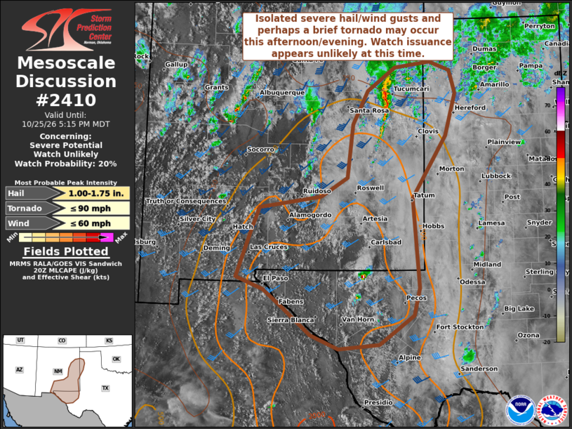
   Areas affected...Portions of southern/eastern New Mexico into far
   west Texas and the western Texas Panhandle

   Concerning...Severe potential...Watch unlikely

   Valid 252048Z - 252315Z

   Probability of Watch Issuance...20 percent

   SUMMARY...Isolated severe hail/wind gusts and perhaps a brief
   tornado may occur this afternoon into early evening. Watch issuance
   appears unlikely at this time.

   DISCUSSION...Compared to locations farther north in NM, parts of far
   west TX have experienced stronger heating in the presence of greater
   low-level moisture (surface dewpoints generally in the upper 50s to
   low 60s). Convective initiation is underway across the higher
   terrain of far west TX/southeast NM. A combination of moderate
   instability and deep-layer shear should prove sufficient for
   thunderstorm organization, including the potential for a supercell
   or two capable of producing isolated severe hail/wind. However,
   better forcing for ascent associated with an ejecting mid-level
   shortwave trough over the Four Corners to the central Rockies will
   likely tend to remain displaced to the north of this region.
   Therefore, current expectations are for strong to severe
   thunderstorm coverage to remain fairly limited across southeast
   NM/far west TX.

   Across east-central NM, a small line segment has recently
   strengthened per radar/satellite imagery. This convection should
   track northeastward into parts of the western TX Panhandle over the
   next couple of hours. Currently, widespread cloudiness is hindering
   boundary-layer destabilization downstream of this activity. But, low
   60s surface temperatures/dewpoints are attempting to stream
   northward along/near an almost stationary front from far
   east-central NM into adjacent areas of the western TX Panhandle. The
   latest VWP from KFDX shows sufficient low-level shear to support
   some risk for a brief tornado, assuming convection can become/remain
   surface based. Isolated severe gusts could also occur.

   For both regions, the overall severe risk is currently expected to
   remain fairly isolated through the afternoon/early evening, and
   watch issuance appears unlikely at this time.

   ..Gleason/Mosier.. 10/25/2026

   ...Please see www.spc.noaa.gov for graphic product...

   ATTN...WFO...LUB...AMA...MAF...ABQ...EPZ...

   LAT...LON   31870703 32720672 33120655 33310525 33660468 34610457
               35210425 35640365 35740291 35580247 35160236 34410258
               33280329 31680316 31190329 30670402 30590487 30840547
               31310603 31650646 31870703

   MOST PROBABLE PEAK TORNADO INTENSITY...UP TO 90 MPH
   MOST PROBABLE PEAK WIND GUST...UP TO 60 MPH
   MOST PROBABLE PEAK HAIL SIZE...1.00-1.75 IN
|
|
|
Top/All Mesoscale Discussions/Forecast Products/Home |
|
Source link