

| Mesoscale Discussion 2399 | |
| < Previous MD | |

|
|
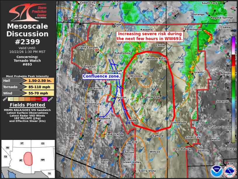
Mesoscale Discussion 2399 NWS Storm Prediction Center Norman OK 0155 PM CDT Thu Oct 22 2026 Areas affected...Parts of east-central and northeast Arizona into far west-central New Mexico Concerning...Tornado Watch 693... Valid 221855Z - 222030Z The severe weather threat for Tornado Watch 693 continues. SUMMARY...The severe risk is expected to increase across parts of east-central and northeast Arizona into far west-central New Mexico during the next few hours. Large hail, severe wind gusts, and a couple of tornadoes will all be possible. DISCUSSION...A north/south-oriented broken band of thunderstorms continues within a confluence zone extending across north-central AZ, with transient organization/embedded rotation. Over the next few hours, this activity, along with additional thunderstorms developing along the higher terrain, will spread northeastward into east-central/northeast AZ into far west-central NM. Here, cloud breaks are supporting diurnal heating/boundary-layer destabilization amid middle/upper 50s dewpoints. Around 70 kt of effective shear (sampled by the FGZ 18Z sounding) and backed low-level winds (and related enhancement to low-level shear/SRH) will be favorable for supercells and organized clusters capable of producing large hail, severe winds gusts, and a couple of tornadoes during the next few hours. ..Weinman.. 10/22/2026 ...Please see www.spc.noaa.gov for graphic product... ATTN...WFO...ABQ...EPZ...TWC...FGZ...PSR... LAT...LON 33311050 33771081 34191098 34591103 35311094 35881045 35990993 35950941 35790905 35040877 33620871 33210891 33060957 33311050 MOST PROBABLE PEAK TORNADO INTENSITY...85-110 MPH MOST PROBABLE PEAK WIND GUST...55-70 MPH MOST PROBABLE PEAK HAIL SIZE...1.50-2.50 IN |
|
|
Top/All Mesoscale Discussions/Forecast Products/Home |
|
Source link