

| Mesoscale Discussion 2393 | |
| < Previous MD | |

|
|
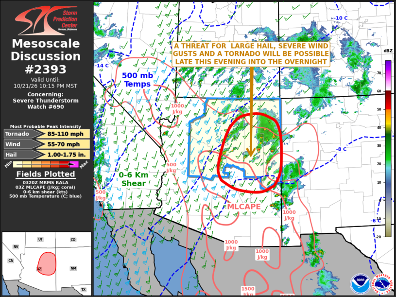
Mesoscale Discussion 2393 NWS Storm Prediction Center Norman OK 1021 PM CDT Wed Oct 21 2026 Areas affected...Central and Eastern Arizona Concerning...Severe Thunderstorm Watch 690... Valid 220321Z - 220515Z The severe weather threat for Severe Thunderstorm Watch 690 continues. SUMMARY...A threat for large hail, severe wind gusts and a tornado will be possible across parts of central and eastern Arizona late this evening into the overnight. DISCUSSION...Recent RAP/water vapor analysis has a 60 to 70 knot mid-level jet streak located over northwestern and north-central Arizona. Lift is likely maximized to the east of this feature across central and eastern Arizona, which is supporting the development of scattered thunderstorms. Over eastern Arizona, surface dewpoints are in the upper 50s F and the RAP has MLCAPE in the 750 to 1000 J/kg. As moisture advection continues overnight, instability is expected to be maintained. In addition, the WSR-88D VWP at Flagstaff shows a long straight hodograph with 55 to 65 knot of flow in the mid-levels. This wind profile will continue to support the potential for supercells with large hail over the next several hours. RAP forecast soundings to the east of Flagstaff have 0-3 km storm-relative helicity remaining in the 200 to 250 m2/s2 range into the early overnight period. This will support an isolated tornado threat with the stronger supercells. ..Broyles.. 10/22/2026 ...Please see www.spc.noaa.gov for graphic product... ATTN...WFO...ABQ...TWC...FGZ...PSR... LAT...LON 35791148 36231103 36391056 36411004 36290960 36050921 35400902 34250906 33690933 33610945 33420991 33431051 33551117 33841175 33871179 34291195 35031179 35791148 MOST PROBABLE PEAK TORNADO INTENSITY...85-110 MPH MOST PROBABLE PEAK WIND GUST...55-70 MPH MOST PROBABLE PEAK HAIL SIZE...1.00-1.75 IN |
|
|
Top/All Mesoscale Discussions/Forecast Products/Home |
|
Source link