

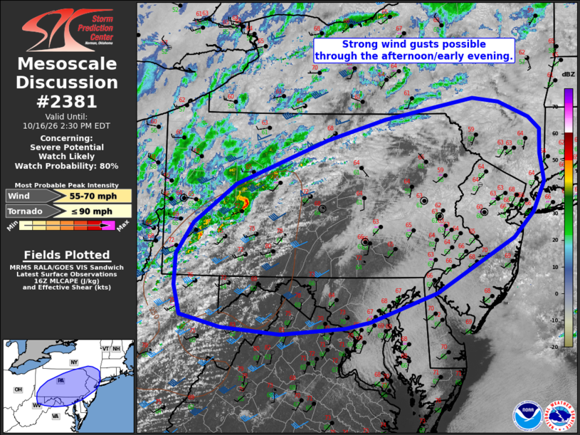
| Mesoscale Discussion 2381 | |
| < Previous MD | |

|
|
   Mesoscale Discussion 2381
   NWS Storm Prediction Center Norman OK
   1156 AM CDT Fri Oct 16 2026

   Areas affected...portions of PA into southern NY...NJ...DE...MD and
   northern WV/VA

   Concerning...Severe potential...Watch likely

   Valid 161656Z - 161830Z

   Probability of Watch Issuance...80 percent

   SUMMARY...Isolated gusty winds may accompany showers and
   thunderstorms over the next couple of hours across portions of
   central PA southwestward into northern WV and western MD. Severe
   potential may increase later this afternoon into early evening
   toward southern NY and the DelMarVa vicinity.

   DISCUSSION...Convection is gradually increasing in intensity across
   western PA early this afternoon along/just ahead of a surface cold
   front. Downstream, stronger heating is occurring within a corridor
   of scattered to broken cloudiness across central PA into adjacent
   portions of WV/western MD. Temperatures have warmed into the 70s
   where this stronger heating has occurred, and weak destabilization
   is underway. While instability and lapse rates are expected to
   remain rather mild, strong deep-layer flow will support transient
   organized bowing structures, and strong gusts at the surface will be
   possible where more substantial heating occurs. Uncertainty exists
   with north and east extent across the Mid-Atlantic/Southern New
   England given persistent stratus and more muted heating. Convective
   trends are being monitored for possible watch issuance.

   ..Leitman/Guyer.. 10/16/2026

   ...Please see www.spc.noaa.gov for graphic product...

   ATTN...WFO...OKX...ALY...PHI...BGM...CTP...LWX...PBZ...RLX...

   LAT...LON   41927646 42207485 42157436 41927381 41757362 41417363
               41037356 40617376 40267413 39497553 39107674 39007719
               38917837 39007944 39188018 39578030 40018028 40457997
               41007920 41637754 41927646

   MOST PROBABLE PEAK TORNADO INTENSITY...UP TO 90 MPH
   MOST PROBABLE PEAK WIND GUST...55-70 MPH
|
|
|
Top/All Mesoscale Discussions/Forecast Products/Home |
|
Source link