

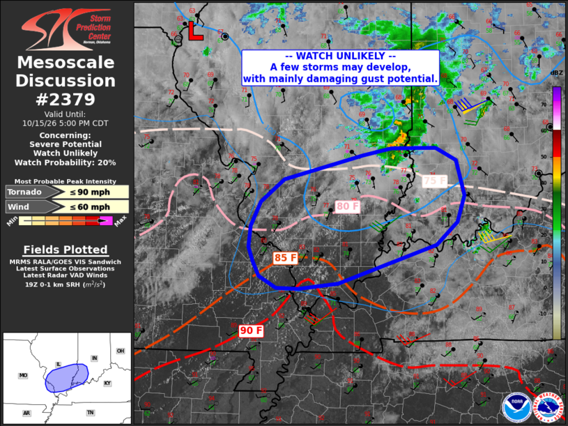
| Mesoscale Discussion 2379 | |
| < Previous MD | |

|
|
   Mesoscale Discussion 2379
   NWS Storm Prediction Center Norman OK
   0259 PM CDT Thu Oct 15 2026

   Areas affected...southeast Missouri...southern Illinois...southwest
   Indiana

   Concerning...Severe potential...Watch unlikely

   Valid 151959Z - 152200Z

   Probability of Watch Issuance...20 percent

   SUMMARY...A few storms may develop later this afternoon from far
   southeast Missouri into southwest Indiana. Locally damaging gusts
   appear to be the main threat.

   DISCUSSION...A diffuse warm front continues to gradually mix
   northward across central IL into southwest IN, with dewpoints
   remaining in the 70s F. Just to the southwest, a low-level lapse
   rate plume extends from AR into southeast MO and toward the Lower OH
   Valley, with temperatures into the lower 90s F and dewpoints mixing
   down well into the 60s F.

   Within the warm advection zone, rain and few thunderstorms are now
   moving out of IL and toward central IN. This activity has locally
   cooled surface temperatures and may provide a relative focus for
   later development.

   Visible imagery does show substantial boundary layer CU from
   southeast MO into southern IL where CIN has been eroded, and a few
   cells could eventually develop there. 1000 J/kg MLCAPE, deep-layer
   shear approaching 40 kt, and a localized area of sufficient
   low-level SRH may yield a small supercell or two capable of strong
   gusts and a low-end chance of a brief tornado, assuming such cells
   survive into the cooler/greater SRH environment.

   ..Jewell.. 10/15/2026

   ...Please see www.spc.noaa.gov for graphic product...

   ATTN...WFO...LMK...IND...PAH...ILX...LSX...

   LAT...LON   37308938 37318974 37469001 37659012 37839019 38109016
               38428999 38718961 39028833 39108786 39108714 38948681
               38498668 38158680 37878715 37378873 37308938

   MOST PROBABLE PEAK TORNADO INTENSITY...UP TO 90 MPH
   MOST PROBABLE PEAK WIND GUST...UP TO 60 MPH
|
|
|
Top/All Mesoscale Discussions/Forecast Products/Home |
|
Source link