

| Mesoscale Discussion 2357 | |
| < Previous MD Next MD > | |

|
|
   Mesoscale Discussion 2357
   NWS Storm Prediction Center Norman OK
   0412 PM CDT Sat Oct 10 2026

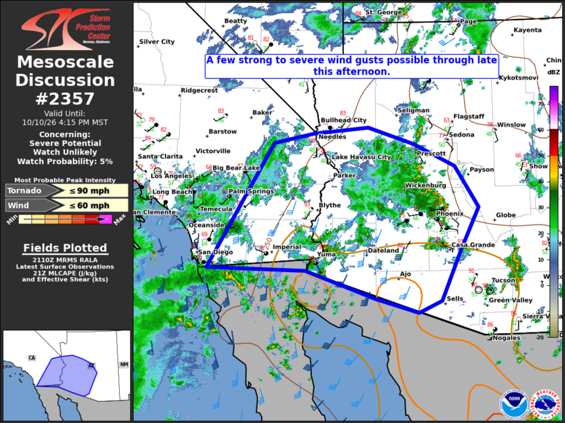
   Areas affected...Southern California and the Lower Colorado River
   Valley into South-Central Arizona

   Concerning...Severe potential...Watch unlikely

   Valid 102112Z - 102315Z

   Probability of Watch Issuance...5 percent

   SUMMARY...Scattered thunderstorms will continue to lift northward
   into southern CA and AZ through late this afternoon. A few strong to
   severe wind gusts will be possible.

   DISCUSSION...Thunderstorm coverage continues to increase across
   northern Baja CA this afternoon with the approach of TS Rachel. Low
   to mid-level moisture advection has slowly been increasing northward
   throughout the day, and will persist through this evening, yielding
   ~1000 J/kg of MLCAPE. In addition, kinematic fields are becoming
   more favorable for some thunderstorm organization across this
   region. The latest mesoscale analysis suggests effective bulk shear
   is beginning to approach 45-50 kt, along with the YUX vad profile.
   DCAPE ~1100 J/kg and storm cell mergers could support severe wind
   gusts up to 60 mph, though limited severe coverage does not warrant
   a thunderstorm watch at this time.

   ..Barnes/Gleason.. 10/10/2026

   ...Please see www.spc.noaa.gov for graphic product...

   ATTN...WFO...TWC...FGZ...PSR...VEF...SGX...

   LAT...LON   32501483 32011336 31741243 31961194 32861151 33631111
               34391161 34791251 35101349 34991466 34811554 32531694
               32501483

   MOST PROBABLE PEAK TORNADO INTENSITY...UP TO 90 MPH
   MOST PROBABLE PEAK WIND GUST...UP TO 60 MPH
|
|
|
Top/All Mesoscale Discussions/Forecast Products/Home |
|
Source link