

| Mesoscale Discussion 2352 | |
| < Previous MD | |

|
|
   Mesoscale Discussion 2352
   NWS Storm Prediction Center Norman OK
   0932 AM CDT Sat Oct 10 2026

   Areas affected...portions of far eastern Georgia into central and
   southern South Carolina

   Concerning...Severe potential...Watch possible

   Valid 101432Z - 101700Z

   Probability of Watch Issuance...40 percent

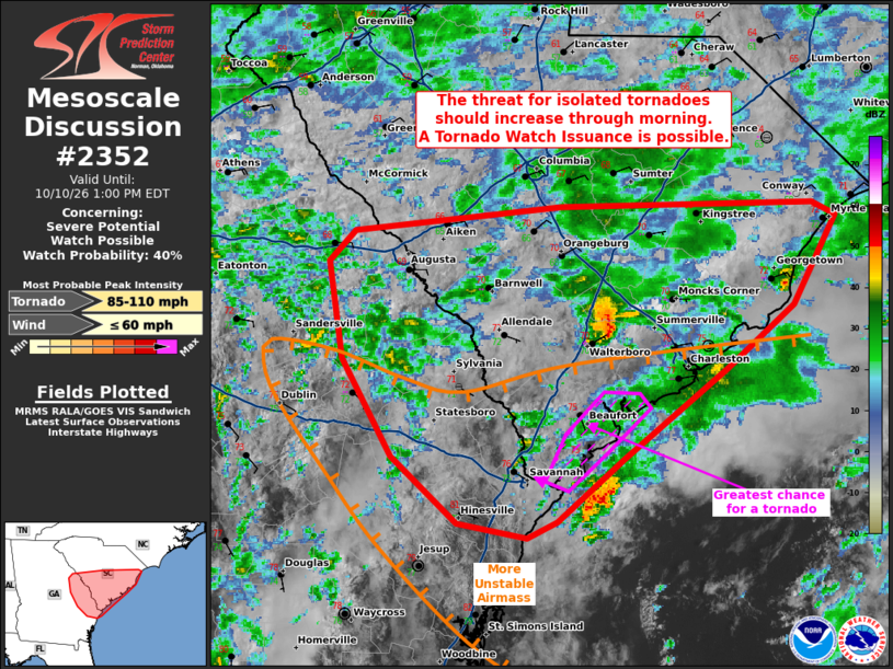
   SUMMARY...The potential for isolated tornadoes will increase through
   the remainder of the morning into the late afternoon hours. The best
   chance for a tornado in the near-term will be with storms making
   landfall on the SC coastline, where the best low-level moisture and
   instability resides.

   DISCUSSION...Diurnal heating is contributing to gradual
   boundary-layer destabilization within the right-front quadrant of
   Isaias' remnants, which should gradually increase the isolated
   tornado threat through the morning hours. At the moment, the best
   airmass resides over southeast GA (between ongoing convection in SC
   and the primary confluence band across central GA). This
   surface-based airmass encompasses mid to upper 70s F surface
   temperatures and equivalent dewpoints, yielding over 1200 J/kg
   MLCAPE (when modifying the 12Z CHS observed sounding). Supercells
   along the SC coastline are showing more persistent low-level
   rotation, and these are the most likely storms to produce a tornado
   over the next couple of hours.

   Despite impressively enlarged/curved hodographs depicted by regional
   VADs (with over 400 m2/s2 0-3 km SRH noted), much of the inland
   airmass remains relatively stable. Given how stable the airmass is
   inland from the coast, the timing of a Tornado Watch remains
   uncertain. However, a watch issuance will be needed at some point
   once surface-base destabilization becomes more widespread.

   ..Squitieri/Smith.. 10/10/2026

   ...Please see www.spc.noaa.gov for graphic product...

   ATTN...WFO...ILM...CHS...CAE...FFC...

   LAT...LON   32208038 31818087 31718109 31808161 32218209 32818244
               33428254 33618236 33768084 33777900 33697884 33157915
               32757964 32208038

   MOST PROBABLE PEAK TORNADO INTENSITY...85-110 MPH
   MOST PROBABLE PEAK WIND GUST...UP TO 60 MPH
|
|
|
Top/All Mesoscale Discussions/Forecast Products/Home |
|
Source link