

| Mesoscale Discussion 2348 | |
| < Previous MD | |

|
|
   Mesoscale Discussion 2348
   NWS Storm Prediction Center Norman OK
   1022 AM CDT Fri Oct 09 2026

   Areas affected...portions of southeast Alabama...the Florida
   Panhandle and southwest Georgia

   Concerning...Severe potential...Tornado Watch likely

   Valid 091522Z - 091745Z

   Probability of Watch Issuance...95 percent

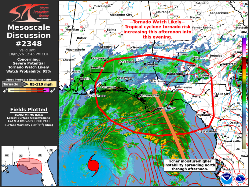
   SUMMARY...The tropical cyclone tornado risk will increase across the
   Florida Panhandle over the next few hours. With time, this risk will
   spread north/northeast into parts of southeast Alabama and southwest
   Georgia through evening. A tornado watch will be issued in the
   17-18z time frame.

   DISCUSSION...Northeasterly low-level winds are still present across
   the region in the vicinity of a stationary front draped across
   northern FL and the north-central Gulf Coast ahead of Hurricane
   Isaias. This boundary will lift northward across north FL and the
   Panhandle as the hurricane progresses toward the coast this
   afternoon. As this occurs, richer boundary layer moisture (mid to
   upper 70s F dewpoints) will overspread the coastal vicinity.
   Likewise, low-level winds will become more east/southeasterly as
   they also continue to increase in magnitude. This will result in
   enlarged, favorably curved low-level hodographs and increasing 0-1
   km SRH favorable for low-level rotation. As richer boundary layer
   moisture arrives, 0-3 km MLCAPE will also increase, supporting
   stronger updrafts and vertical motion within supercell storms
   contained in outer rain bands moving across the FL Peninsula. This
   trend has already been noted within a stronger rain band over the
   offshore waters to the south of the FL Panhandle and Big Bend
   vicinity.

   The tornado risk will increase across the FL Panhandle by early to
   mid afternoon, with the risk gradually spreading northward toward
   southeast AL/southwest GA this evening.

   ..Leitman/Smith.. 10/09/2026

   ...Please see www.spc.noaa.gov for graphic product...

   ATTN...WFO...TBW...JAX...TAE...MOB...

   LAT...LON   29838728 30228739 30618739 31338701 31458668 31628528
               31478421 31328351 31048297 30818278 29498271 29128293
               28928377 28858491 28968584 29358676 29838728

   MOST PROBABLE PEAK TORNADO INTENSITY...85-110 MPH
|
|
|
Top/All Mesoscale Discussions/Forecast Products/Home |
|
Source link