

| Mesoscale Discussion 2345 | |
| < Previous MD | |

|
|
   Mesoscale Discussion 2345
   NWS Storm Prediction Center Norman OK
   0132 PM CDT Thu Oct 01 2026

   Areas affected...portions of southwestern Kansas into far
   northwestern Oklahoma

   Concerning...Severe potential...Watch unlikely

   Valid 011832Z - 012100Z

   Probability of Watch Issuance...5 percent

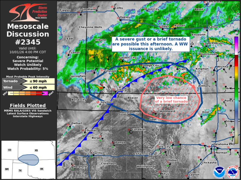
   SUMMARY...A couple of severe gusts and perhaps a brief tornado are
   possible this afternoon. Given the sparse nature of the severe
   threat, a WW issuance is not expected.

   DISCUSSION...A 500 mb cyclone continues to slowly drift eastward
   across the southern High Plains, accompanied by gradual
   destabilization (given widespread cloud cover). A cold front extends
   northeast from central KS to the TX Panhandle and is sagging
   southward from beneath the 500 mb cyclone. To the south and east of
   this front resides a marginally unstable airmass, characterized by
   mid 60s F surface dewpoints beneath 6.5 C/km mid-level lapse rates,
   as sampled by the 18Z DDC observed sounding.

   Given ongoing widespread clouds and precipitation, it is unclear how
   much additional destabilization will occur. Several storms undercut
   by the front have managed to produce multiple 40-50 kt gusts per
   regional ASOS/AWOS, roughly from Hamilton to Finney Counties in
   southwest KS. Assuming some surface gradient flow enhancement is
   underway, similar gusts may continue this afternoon. The best chance
   for a brief tornado will be with storms interacting with locally
   stronger ambient vertical vorticity not undercut by the front. At
   the moment, the best area would be in the warm sector along the
   KS/OK border. Nonetheless, the severe threat should remain too
   localized and brief to warrant a WW issuance.

   ..Squitieri/Gleason.. 10/01/2026

   ...Please see www.spc.noaa.gov for graphic product...

   ATTN...WFO...ICT...OUN...DDC...AMA...

   LAT...LON   37280194 37750101 37860010 37899898 37729842 37419805
               37219792 36729788 36349817 36149863 36149921 36229986
               36410038 36710124 36960184 37280194

   MOST PROBABLE PEAK TORNADO INTENSITY...UP TO 90 MPH
   MOST PROBABLE PEAK WIND GUST...UP TO 60 MPH
|
|
|
Top/All Mesoscale Discussions/Forecast Products/Home |
|
Source link