

| Mesoscale Discussion 2344 | |
| < Previous MD | |

|
|
   Mesoscale Discussion 2344
   NWS Storm Prediction Center Norman OK
   1123 PM CDT Wed Sep 30 2026

   Areas affected...central Oklahoma into northwest Texas

   Concerning...Severe potential...Watch unlikely

   Valid 010423Z - 010630Z

   Probability of Watch Issuance...20 percent

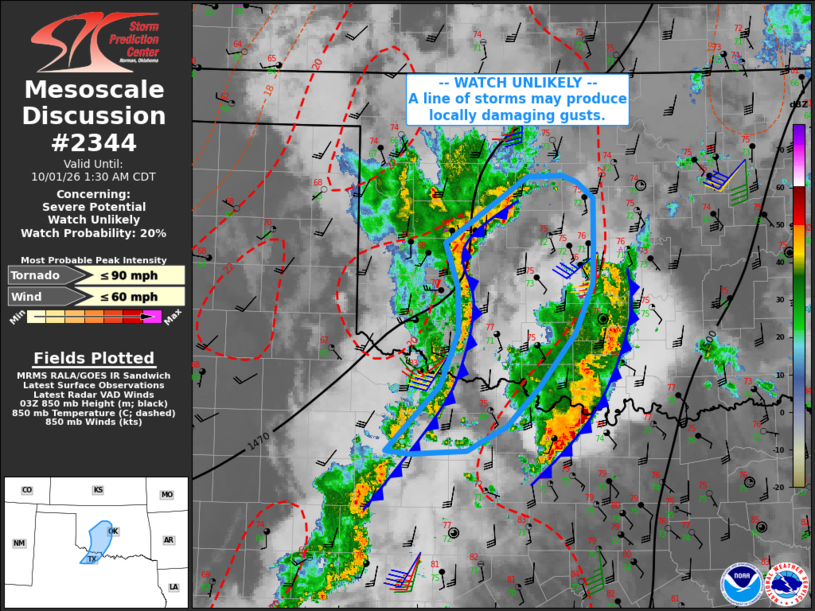
   SUMMARY...A line of storms may produce strong gusts of 40-50 mph as
   it moves into central Oklahoma. Isolated damaging gusts cannot be
   ruled out.

   DISCUSSION...A line of storms continues to move across southwest OK,
   with wind gusts over 40 mph reported and strong pressure rises noted
   on the mesonet. A slower moving portion of this system extends from
   Blaine into Washita Counties, with higher echo tops noted.

   VWPs indicate south/southwest boundary layer flow continues across
   the region, with up to 40 kt near 1 km AGL. This should maintain
   northward moisture flux ahead of the approaching line of storms and
   wind shift, and some uptick in intensity is possible. A larger
   leading cluster over south-central OK may modify the environment
   somewhat, but appears to be far enough removed from the western
   activity to not weaken it much.

   ..Jewell/Hart.. 10/01/2026

   ...Please see www.spc.noaa.gov for graphic product...

   ATTN...WFO...OUN...

   LAT...LON   33489966 34089905 34599885 35019885 35419900 36049807
               36049766 35999750 35839731 35359731 35049733 34599752
               34089793 33709830 33479875 33449937 33489966

   MOST PROBABLE PEAK TORNADO INTENSITY...UP TO 90 MPH
   MOST PROBABLE PEAK WIND GUST...UP TO 60 MPH
|
|
|
Top/All Mesoscale Discussions/Forecast Products/Home |
|
Source link