

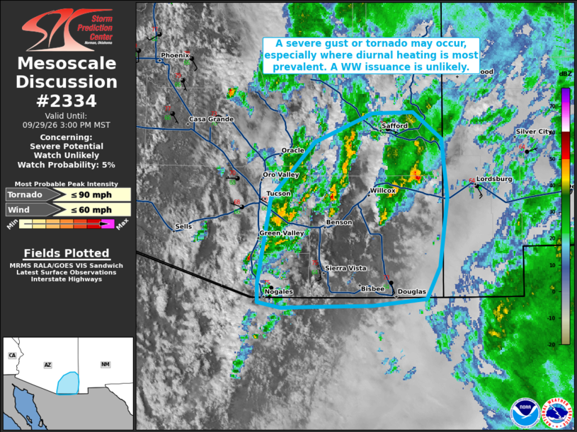
| Mesoscale Discussion 2334 | |
| < Previous MD | |

|
|
   Mesoscale Discussion 2334
   NWS Storm Prediction Center Norman OK
   0326 PM CDT Tue Sep 29 2026

   Areas affected...portions of southeastern Arizona

   Concerning...Severe potential...Watch unlikely

   Valid 292026Z - 292200Z

   Probability of Watch Issuance...5 percent

   SUMMARY...A severe gust or brief tornado may occur with one of the
   stronger storms this afternoon. The severe threat should remain
   sparse, with a WW issuance not anticipated.

   DISCUSSION...Clearing skies and boundary-layer heating/mixing ahead
   of a confluence zone, accompanying an approaching inverted surface
   trough, will support continued gradual convective intensification
   through the day. MRMS mosaic radar imagery has shown strengthening
   storms over eastern Pima to eastern Cochise counties over the past
   hours. With surface temperatures reaching 70+ F in spots, amid low
   60s F dewpoints, additional storm development is likely ahead of a
   developing 500 mb low over southeastern AZ. Buoyancy exceeds 500
   J/kg MLCAPE over this region, along with 40+ kts of effective bulk
   shear. Any of the stronger storms that can root into the boundary
   layer may become surface based and spawn either a brief tornado or
   severe gust. Given the expected isolated nature of the severe
   threat. A WW issuance is not expected.

   ..Squitieri/Mosier.. 09/29/2026

   ...Please see www.spc.noaa.gov for graphic product...

   ATTN...WFO...EPZ...TWC...

   LAT...LON   31610908 31310922 31250978 31241043 31231075 31291100
               31461100 32221085 32721040 32980978 32990935 32750906
               32220900 31610908

   MOST PROBABLE PEAK TORNADO INTENSITY...UP TO 90 MPH
   MOST PROBABLE PEAK WIND GUST...UP TO 60 MPH
|
|
|
Top/All Mesoscale Discussions/Forecast Products/Home |
|
Source link