

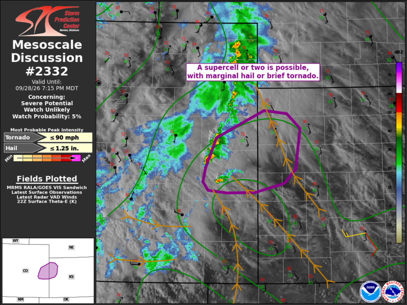
| Mesoscale Discussion 2332 | |
| < Previous MD | |

|
|
   Mesoscale Discussion 2332
   NWS Storm Prediction Center Norman OK
   0542 PM CDT Mon Sep 28 2026

   Areas affected...east-central Colorado into northwest Kansas

   Concerning...Severe potential...Watch unlikely

   Valid 282242Z - 290115Z

   Probability of Watch Issuance...5 percent

   SUMMARY...A cell or two may produce hail over 1.00", or perhaps a
   brief/weak tornado.

   DISCUSSION...Storms are forming over east-central CO, near a surface
   trough. This trough continues to deepen per surface observations,
   with convergence maximized in that area. These cells are also within
   the instability/theta-e axis, with southerly winds bringing warmer
   air northward.

   Objective analysis indicates 0-1 SRH near 100 m2/s2, with backed
   surface winds from southeast CO into southwest KS where temperatures
   are warming. Although the ongoing cells are farther north, the
   southernmost cells may eventually access the more favorable
   environment, with hail possible. Boundary-layer T/Td spreads are
   reasonable to support a brief tornado as well given the sufficient
   low-level shear.

   ..Jewell/Hart.. 09/28/2026

   ...Please see www.spc.noaa.gov for graphic product...

   ATTN...WFO...GLD...PUB...

   LAT...LON   38780306 39240285 39650192 39610146 39380121 38750130
               38530152 38400208 38380264 38420302 38560312 38780306

   MOST PROBABLE PEAK TORNADO INTENSITY...UP TO 90 MPH
   MOST PROBABLE PEAK HAIL SIZE...UP TO 1.25 IN
|
|
|
Top/All Mesoscale Discussions/Forecast Products/Home |
|
Source link