

| Mesoscale Discussion 2310 | |
| < Previous MD | |

|
|
   Mesoscale Discussion 2310
   NWS Storm Prediction Center Norman OK
   0243 PM CDT Sat Sep 19 2026

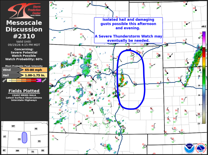
   Areas affected...Northeast/East-Central CO

   Concerning...Severe potential...Watch possible

   Valid 191943Z - 192215Z

   Probability of Watch Issuance...60 percent

   SUMMARY...Isolated hail and strong gusts are possible across
   northeast/north-central Colorado this afternoon. A Severe
   Thunderstorm Watch may be needed at some point later this afternoon
   when a convective line forms.

   DISCUSSION...Thunderstorm intensity over the immediate foothills of
   the Colorado Front Range (i.e. Arapahoe and Elbert counties) has
   increase quickly during the past half hour. This activity appears to
   be associated with modest glancing large-scale ascent attendant to a
   vorticity max moving through southeast WY. The downstream airmass is
   moist and moderately unstable, and the general expectation is for
   this initial activity to grow upscale into a coherent convective
   line over time.

   Severe potential should remain isolated initially, with large hail
   as the primary risk. Once the line segment materializes, the primary
   threat will shift to wind gusts, with several strong to severe gusts
   (i.e. 60 to 75 mph) possible. It may take some time for the upscale
   growth to occur, but trends are being monitored closely, and a
   Severe Thunderstorm Watch may be needed when this line forms.

   ..Mosier.. 09/19/2026

   ...Please see www.spc.noaa.gov for graphic product...

   ATTN...WFO...GLD...PUB...BOU...

   LAT...LON   39610473 40590461 40810406 40610344 40230322 39630317
               38890315 38440332 38140376 38360455 39610473

   MOST PROBABLE PEAK WIND GUST...65-80 MPH
   MOST PROBABLE PEAK HAIL SIZE...1.00-1.75 IN
|
|
|
Top/All Mesoscale Discussions/Forecast Products/Home |
|
Source link