

| Mesoscale Discussion 2297 | |
| < Previous MD | |

|
|
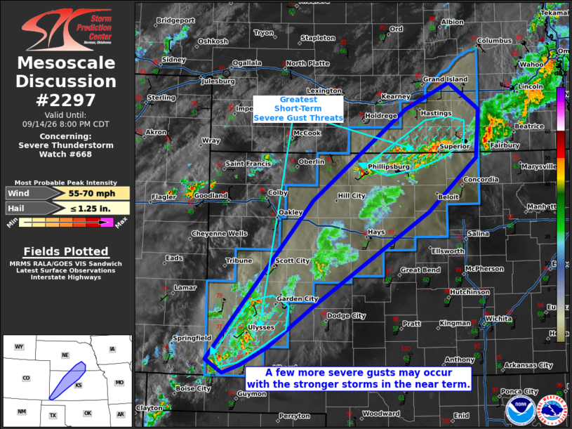
Mesoscale Discussion 2297 NWS Storm Prediction Center Norman OK 0653 PM CDT Mon Sep 14 2026 Areas affected...portions of western Kansas into southern Nebraska Concerning...Severe Thunderstorm Watch 668... Valid 142353Z - 150100Z The severe weather threat for Severe Thunderstorm Watch 668 continues. SUMMARY...A few severe gusts may accompany some of the stronger thunderstorms over the next few hours. DISCUSSION...Several thunderstorm clusters have produced severe gusts with initial outflow surges. Several of these storms have become undercut and have weakened or dissipated. Still, where the boundary layer remains relatively pristine (i.e. mixed and unstable), severe gust potential still exists. At the moment, the best chance for additional severe gusts in the next hour or so will be over portions of far southwestern KS and the north-central KS to south-central NE border, where stronger storms may be interacting with the mixed boundary layer. With time, the severe threat should diminish as propagating outflow contaminates most of the warm sector encompassing the watch area. ..Squitieri.. 09/14/2026 ...Please see www.spc.noaa.gov for graphic product... ATTN...WFO...OAX...TOP...ICT...GID...DDC...GLD...PUB... LAT...LON 37200205 39360024 40599863 40939787 40579735 39939740 39209823 37910025 37370100 37140146 37030176 37200205 MOST PROBABLE PEAK WIND GUST...55-70 MPH MOST PROBABLE PEAK HAIL SIZE...UP TO 1.25 IN |
|
|
Top/All Mesoscale Discussions/Forecast Products/Home |
|
Source link