

| Mesoscale Discussion 2293 | |
| < Previous MD | |

|
|
   Mesoscale Discussion 2293
   NWS Storm Prediction Center Norman OK
   0309 PM CDT Mon Sep 14 2026

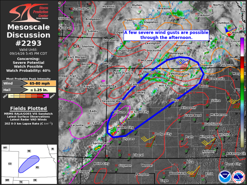
   Areas affected...Parts of western Kansas into south-central Nebraska

   Concerning...Severe potential...Watch possible

   Valid 142009Z - 142245Z

   Probability of Watch Issuance...40 percent

   SUMMARY...Thunderstorms should increase in coverage through the
   remainder of the afternoon into early this evening. The stronger
   storms will be capable of producing a few severe wind gusts.

   DISCUSSION...Isolated high-based thunderstorms are evolving within a
   NE/SW-oriented surface trough in southwestern KS, with additional
   deepening cumulus embedded within a zone of warm advection over
   north-central KS and south-central NE. In southwestern KS, the
   modified 18Z DDC sounding depicts steep low/midlevel lapse rates and
   30-40 kt of southwesterly flow through the depth of the boundary
   layer. This will promote robust thunderstorm downdrafts, with a risk
   of severe wind gusts -- especially with any small clusters that
   evolve. Farther northeast, thunderstorm development/intensification
   is more uncertain, given the persistent cloud coverage and showers.
   Nevertheless, temperatures have warmed into the lower/middle 90s
   amid 40-45 kt of flow in the lowest 2 km AGL (per UEX VWP data).
   Therefore, any thunderstorms that mature in this environment will
   also pose a risk of severe wind gusts through the afternoon and
   early evening. It is unclear if the severe risk will warrant a
   watch, though convective trends are being monitored.

   ..Weinman/Guyer.. 09/14/2026

   ...Please see www.spc.noaa.gov for graphic product...

   ATTN...WFO...TOP...ICT...GID...DDC...GLD...

   LAT...LON   38510178 39170114 39870023 40299944 40389891 40349851
               40189812 39799788 39499806 37750121 37680174 37830198
               38160198 38510178

   MOST PROBABLE PEAK WIND GUST...65-80 MPH
   MOST PROBABLE PEAK HAIL SIZE...UP TO 1.25 IN
|
|
|
Top/All Mesoscale Discussions/Forecast Products/Home |
|
Source link