

| Mesoscale Discussion 2241 | |
| < Previous MD | |
|
|
   Mesoscale Discussion 2241
   NWS Storm Prediction Center Norman OK
   0940 AM CDT Sat Sep 05 2026

   Areas affected...Parts of eastern KY/TN into far southern
   WV...southwest VA...western NC

   Concerning...Severe potential...Watch possible

   Valid 051440Z - 051615Z

   Probability of Watch Issuance...40 percent

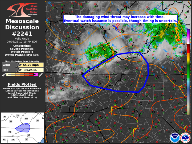
   SUMMARY...The damaging-wind threat may increase with time. Eventual
   watch issuance is possible for parts of the region, though timing is
   uncertain.

   DISCUSSION...A remnant MCS and attendant MCV are moving
   southeastward toward southern VA this morning, while another small
   cluster has recently intensified over eastern KY. Diurnal
   heating/destabilization is underway downstream, with MLCAPE expected
   to increase to near/above 2000 J/kg despite poor midlevel lapse
   rates. Storm intensification and/or redevelopment is expected with
   time through the day, as convective temperatures (generally upper
   80s to low 90s F at lower elevations per regional 12Z soundings) are
   reached. Steepening low-level lapse rates and relatively large PW
   will support potential for localized downbursts. Modest
   unidirectional west-northwesterly flow will allow for development
   and maintenance of one or more loosely organized clusters, resulting
   in potential for swaths of somewhat greater wind-damage potential.

   The longevity of the ongoing cluster across eastern KY as it crosses
   the mountains is uncertain. However, eventual watch issuance is
   possible if the ongoing cluster persists, or vigorous downstream
   storm development appears imminent.

   ..Dean/Gleason.. 09/05/2026

   ...Please see www.spc.noaa.gov for graphic product...

   ATTN...WFO...RNK...RLX...GSP...MRX...JKL...

   LAT...LON   37428190 37498118 37478071 37038032 36568030 36068054
               35858082 35898196 36118326 36528368 36738340 37428190

   MOST PROBABLE PEAK WIND GUST...55-70 MPH
   MOST PROBABLE PEAK HAIL SIZE...UP TO 1.25 IN
|
|
|
Top/All Mesoscale Discussions/Forecast Products/Home |
|
Source link