

| Mesoscale Discussion 2170 | |
| < Previous MD Next MD > | |
|
|
   Mesoscale Discussion 2170
   NWS Storm Prediction Center Norman OK
   0604 PM CDT Sat Aug 29 2026

   Areas affected...far eastern NV into central and northern UT

   Concerning...Severe potential...Watch possible

   Valid 292304Z - 300100Z

   Probability of Watch Issuance...40 percent

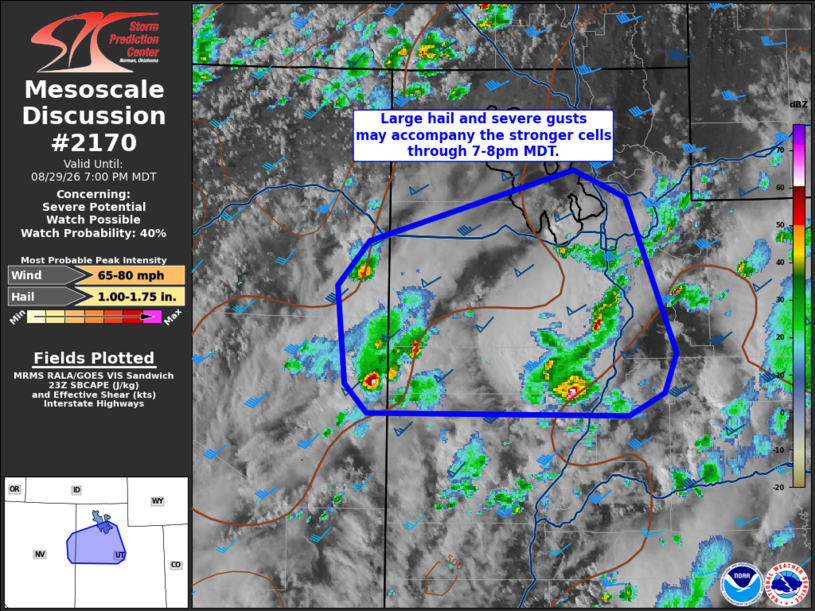
   SUMMARY...Large hail and severe gusts may accompany the stronger
   cells through 7-8pm MDT.

   DISCUSSION...Latest radar mosaic shows a few cells, the most notable
   of which are moving east over White Pine Co. NV and Juab Co. UT.
   Ample deep-layer shear (50 kt) and moderate buoyancy (1000-1500 J/kg
   SBCAPE) are favoring storm organization into stronger updraft/cell
   development.  Despite some cloud cover and minor influence from
   earlier day convection, the optimal time-of-day via peak heating and
   steepening of low-level lapse rates downstream of the ongoing storm
   activity, likely promotes a maintenance of the severe threat with
   the stronger storms for the next few hours.

   ..Smith.. 08/29/2026

   ...Please see www.spc.noaa.gov for graphic product...

   ATTN...WFO...SLC...LKN...

   LAT...LON   39401424 39611446 40361454 40691423 41231222 41021170
               39841121 39551133 39371169 39401424

   MOST PROBABLE PEAK WIND GUST...65-80 MPH
   MOST PROBABLE PEAK HAIL SIZE...1.00-1.75 IN
|
|
|
Top/All Mesoscale Discussions/Forecast Products/Home |
|
Source link