

| Mesoscale Discussion 2161 | |
| < Previous MD | |

|
|
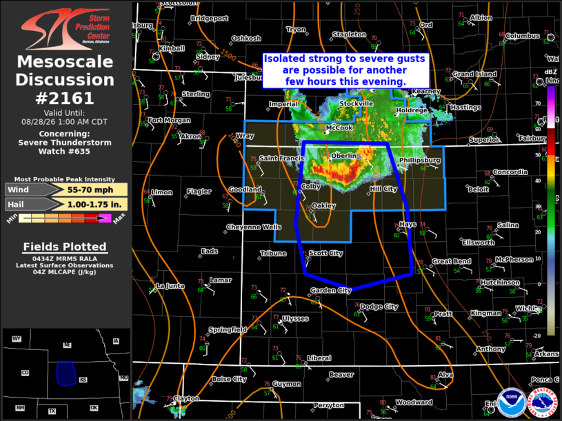
Mesoscale Discussion 2161 NWS Storm Prediction Center Norman OK 1137 PM CDT Thu Aug 27 2026 Areas affected...portions of northwest and west-central Kansas Concerning...Severe Thunderstorm Watch 635... Valid 280437Z - 280600Z The severe weather threat for Severe Thunderstorm Watch 635 continues. SUMMARY...Isolated strong to severe gusts will remain possible with the small bowing complex moving southward tonight. How long the complex remains severe is uncertain, but an isolated wind risk may persist for a few more hours. A downstream watch is not expected, but convective trends will be monitored. DISCUSSION...The ongoing bowing complex near the KS/NE state line has remained relatively intense as it moved southward this evening across WW635. However, MRMS 7km CAPPI and Echo Tops show the stronger cores have begun to lose some intensity in the last hour. This is forecast to continue as the complex moves farther south into increasing nocturnal inhibition. Despite the weakening trend, recent measured gusts of 58 and 60 mph in Decatur County, KS show the bowing segment remains severe. The risk for at least isolated strong to severe gusts may persist for another few hours tonight into west-central KS before the complex weakens below severe limits. How far south this may occur remains unclear. WW635 has been extended in time and area to 0600z and a downstream WW is not currently anticipated. Convective trends will be monitored if more than an isolated severe risk develops. ..Lyons.. 08/28/2026 ...Please see www.spc.noaa.gov for graphic product... ATTN...WFO...GID...DDC...GLD... LAT...LON 40060098 40059951 39159916 38269908 38050012 38260093 38940111 40060098 MOST PROBABLE PEAK WIND GUST...55-70 MPH MOST PROBABLE PEAK HAIL SIZE...1.00-1.75 IN |
|
|
Top/All Mesoscale Discussions/Forecast Products/Home |
|
Source link