

| Mesoscale Discussion 2155 | |
| < Previous MD | |

|
|
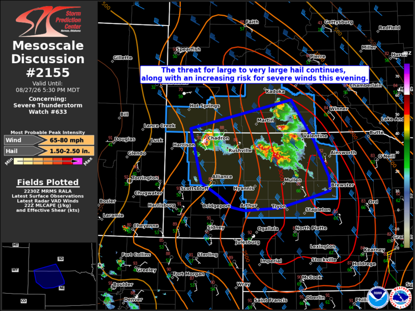
Mesoscale Discussion 2155 NWS Storm Prediction Center Norman OK 0533 PM CDT Thu Aug 27 2026 Areas affected...portions of southern South Dakota and central Nebraska Concerning...Severe Thunderstorm Watch 633... Valid 272233Z - 272330Z The severe weather threat for Severe Thunderstorm Watch 633 continues. SUMMARY...A cluster of supercells will remain capable of large to very large hail this evening. With time, upscale growth into a cluster could promote an increasing risk for severe wind gusts. DISCUSSION...As of 2230 UTC, regional radar imagery showed a cluster of well-developed supercells ongoing over far southern SD and north-central NE. 3000 J/kg of MLCAPE and 40-50 kt of northwesterly deep-layer shear should continue to promote supercell structures with strong updrafts. Steep mid-level lapse rates (8-9 C/km) and 500 mb temps of -10 to -11C will support hail with these storms. Some hail could be 2+ inches in diameter, especially with the more discrete storms on the western end of the ongoing cluster. Numerous storm interactions with storm splits are being observed over Cherry County, NE and far southern SD. Continued clustering and upscale growth appear likely over the next couple of hours and is also supported by short term model guidance. Further upscale growth, the strongly buoyant environment and sufficient deep-layer shear may favor an increasing risk of damaging gusts. A few gusts of 75+ mph are possible over central and possibly southern NE later this evening if a sufficiently strong cold pool is able to become established. ..Lyons.. 08/27/2026 ...Please see www.spc.noaa.gov for graphic product... ATTN...WFO...LBF...UNR...CYS... LAT...LON 43070341 43610083 42860025 42159987 41899986 41780026 41570114 41520201 41580234 41810270 42050311 43070341 MOST PROBABLE PEAK WIND GUST...65-80 MPH MOST PROBABLE PEAK HAIL SIZE...1.50-2.50 IN |
|
|
Top/All Mesoscale Discussions/Forecast Products/Home |
|
Source link