

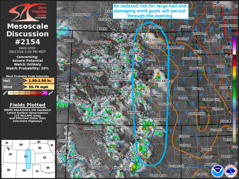
| Mesoscale Discussion 2154 | |
| < Previous MD | |

|
|
   Mesoscale Discussion 2154
   NWS Storm Prediction Center Norman OK
   0402 PM CDT Thu Aug 27 2026

   Areas affected...portions of the central and southern High Plains

   Concerning...Severe potential...Watch unlikely

   Valid 272102Z - 272300Z

   Probability of Watch Issuance...20 percent

   SUMMARY...Widely scattered thunderstorms will bring an isolated risk
   for large hail and damaging wind gusts through this evening.

   DISCUSSION...Widely scattered convection has developed along the
   Front Range of Colorado and the Raton Meso/southern Sangre de Cristo
   Mountains in northeastern New Mexico as of 2045 UTC. Surface
   observations suggest temperatures are near 90 F with dewpoints in
   the upper 40s to lower 50s downstream across the High Plains, which
   is supporting 500 to locally 1500 J/kg MLCAPE. This area is
   displaced to the south of stronger mid- and upper-level flow, with
   only 20-30 kts of effective shear noted across the region. This is
   sufficient to support a mix of clusters and marginal supercell
   structures, however. Steep low- and mid-level lapse rates along with
   dry, well-mixed boundary layer profiles (LCLs of 2000-2500+ m) will
   support a risk for large hail and damaging wind gusts with this
   convection.  However, watch issuance appears unlikely at this time
   as lingering inhibition (indicated by recent objective analysis) and
   only modest effective shear are expected to temper overall severe
   risk and spatially confine it to the higher terrain and Foothills.

   ..Chalmers/Mosier.. 08/27/2026

   ...Please see www.spc.noaa.gov for graphic product...

   ATTN...WFO...PUB...BOU...CYS...ABQ...

   LAT...LON   38730563 37080551 35800534 35580524 35400506 35300483
               35270443 35410417 35640400 35960385 36760377 39640362
               40320362 40790377 41120402 41280427 41440466 41350502
               41060540 40600558 38730563

   MOST PROBABLE PEAK WIND GUST...55-70 MPH
   MOST PROBABLE PEAK HAIL SIZE...1.50-2.50 IN
|
|
|
Top/All Mesoscale Discussions/Forecast Products/Home |
|
Source link