

| Mesoscale Discussion 2152 | |
| < Previous MD Next MD > | |
|
|
   Mesoscale Discussion 2152
   NWS Storm Prediction Center Norman OK
   0349 PM CDT Thu Aug 27 2026

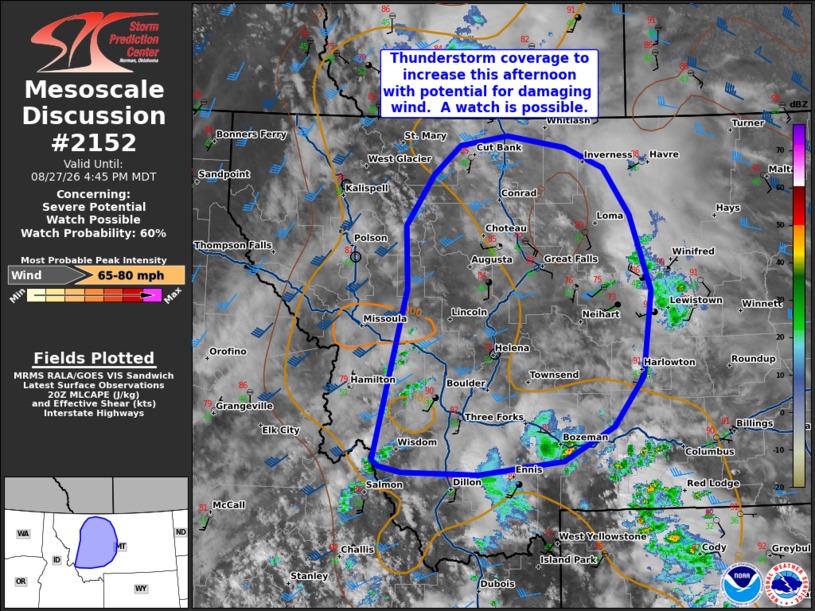
   Areas affected...portions of western and central Montana

   Concerning...Severe potential...Watch possible

   Valid 272049Z - 272245Z

   Probability of Watch Issuance...60 percent

   SUMMARY...Thunderstorm coverage to increase through the afternoon,
   with potential for damaging wind. A watch will be possible.

   DISCUSSION...Forcing for ascent is overspreading portions of Idaho
   into western Montana from an upstream trough across the Pacific
   Northwest. This will likely lead to an increase in thunderstorm
   development across western Montana this afternoon. Initially,
   thunderstorms will form near the high terrain before spreading
   eastward through the lower valleys late afternoon/evening.

   Though cirrus has been present, filtered daytime heating across the
   lower terrain has yielded temperatures in the 90s F. Surface dew
   points are generally in the mid-40s to 50s, with mainly mid-level
   moisture contributing to thunderstorm development. While moisture is
   modest, surface heating has allowed for steepening mid-level lapse
   rates and marginal instability (with MLCAPE around 500 J/kg).  Large
   dew point depressions and steep low-level lapse rates will likely
   result in outflow dominate storms with the primary threat of
   damaging wind. Guidance suggests that one or more clusters may
   emerge and spread north and east through the evening, which may
   produce more focused corridors of severe gusts around 60-75+ mph. A
   watch will be possible this evening to cover this potential.

   ..Thornton/Mosier.. 08/27/2026

   ...Please see www.spc.noaa.gov for graphic product...

   ATTN...WFO...BYZ...TFX...MSO...

   LAT...LON   47251331 47901334 48421292 48721252 48811182 48701095
               48491036 48000997 47240967 46360980 45851024 45501097
               45351223 45371337 45441370 45491380 47251331

   MOST PROBABLE PEAK WIND GUST...65-80 MPH
|
|
|
Top/All Mesoscale Discussions/Forecast Products/Home |
|
Source link