

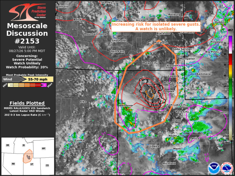
| Mesoscale Discussion 2153 | |
| < Previous MD Next MD > | |

|
|
   Mesoscale Discussion 2153
   NWS Storm Prediction Center Norman OK
   0355 PM CDT Thu Aug 27 2026

   Areas affected...northern Utah into southeast Idaho

   Concerning...Severe potential...Watch unlikely

   Valid 272055Z - 272300Z

   Probability of Watch Issuance...20 percent

   SUMMARY...The threat for isolated severe wind gusts is expected to
   increase through the remainder of this afternoon into early evening.
   The areal coverage of the threat is expected to remain too limited
   for a watch consideration.

   DISCUSSION...Ahead of a subtle disturbance embedded within a moist,
   mid-level flow regime, a band of thunderstorms is ongoing across
   eastern Elko County NV and western Tooele County UT as of 2045Z.
   RAP-based proximity soundings indicate a well-mixed, 3-km deep
   boundary layer with MLCAPE of generally less than 500 J/kg. Some
   increase in deep-layer shear is forecast this afternoon, which
   coupled with the presence of steep low/mid-level lapse rates and
   strong evaporational-cooling potential in the sub-cloud layer will
   support a few severe wind gusts as convection progresses from
   southwest through northeast across the region.

   ..Mead/Mosier.. 08/27/2026

   ...Please see www.spc.noaa.gov for graphic product...

   ATTN...WFO...SLC...PIH...LKN...

   LAT...LON   40961417 42101367 43011221 42511145 41161137 40251199
               39911310 39851355 40221417 40961417

   MOST PROBABLE PEAK WIND GUST...55-70 MPH
|
|
|
Top/All Mesoscale Discussions/Forecast Products/Home |
|
Source link