

| Mesoscale Discussion 2150 | |
| < Previous MD | |
|
|
   Mesoscale Discussion 2150
   NWS Storm Prediction Center Norman OK
   0220 PM CDT Thu Aug 27 2026

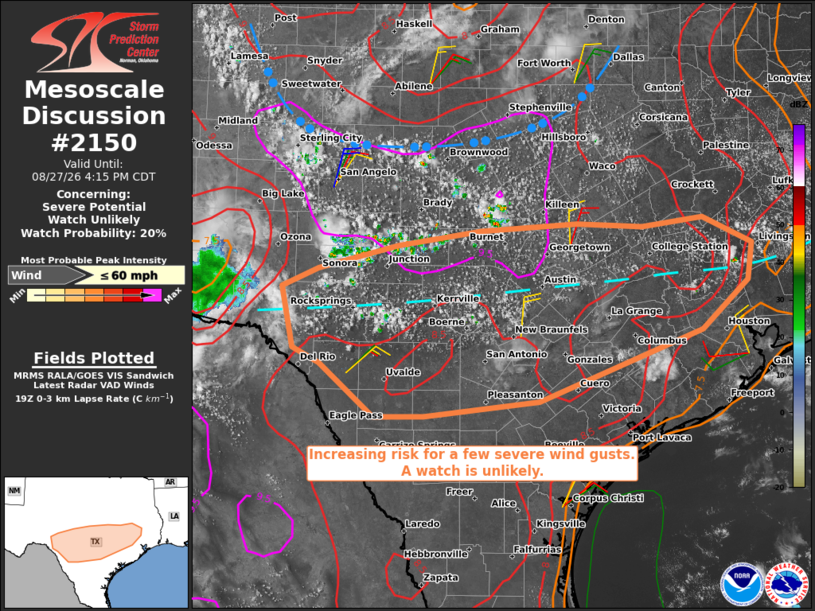
   Areas affected...portions of south-central and southeast Texas

   Concerning...Severe potential...Watch unlikely

   Valid 271920Z - 272115Z

   Probability of Watch Issuance...20 percent

   SUMMARY...Isolated wind gusts appear possible from late afternoon
   through this evening. The areal coverage of the threat is expected
   to remain too isolated for a watch consideration.

   DISCUSSION...Ahead of an MCV moving through the Red River Valley,
   visible satellite shows deepening cumulus and a few thunderstorms
   from the Concho Valley to Hill Country, with additional cumulus
   noted along a surface trough from San Antonio to Rock Springs.
   Latest objective analysis suggests some lingering convective
   inhibition; however, continued daytime heating will support further
   air mass destabilization with a gradual increase in thunderstorms
   expected over the next 1-3 hours. Weak vertical shear will limit the
   potential for storm organization; however, the presence of a
   relatively deep, well-mixed boundary layer will be supportive of
   isolated wind gusts with any more intense pulse storms.

   ..Mead/Mosier.. 08/27/2026

   ...Please see www.spc.noaa.gov for graphic product...

   ATTN...WFO...HGX...FWD...EWX...SJT...

   LAT...LON   29380063 29550097 30240112 30450065 30719962 30899854
               30969728 30929642 31029564 30739500 30319506 29759566
               28969777 28799926 28779991 29380063

   MOST PROBABLE PEAK WIND GUST...UP TO 60 MPH
|
|
|
Top/All Mesoscale Discussions/Forecast Products/Home |
|
Source link