

| Mesoscale Discussion 2135 | |
| < Previous MD | |
|
|
   Mesoscale Discussion 2135
   NWS Storm Prediction Center Norman OK
   1020 PM CDT Tue Aug 25 2026

   Areas affected...portions of extreme southwestern Oklahoma into
   northwestern Texas

   Concerning...Severe potential...Watch unlikely

   Valid 260320Z - 260415Z

   Probability of Watch Issuance...20 percent

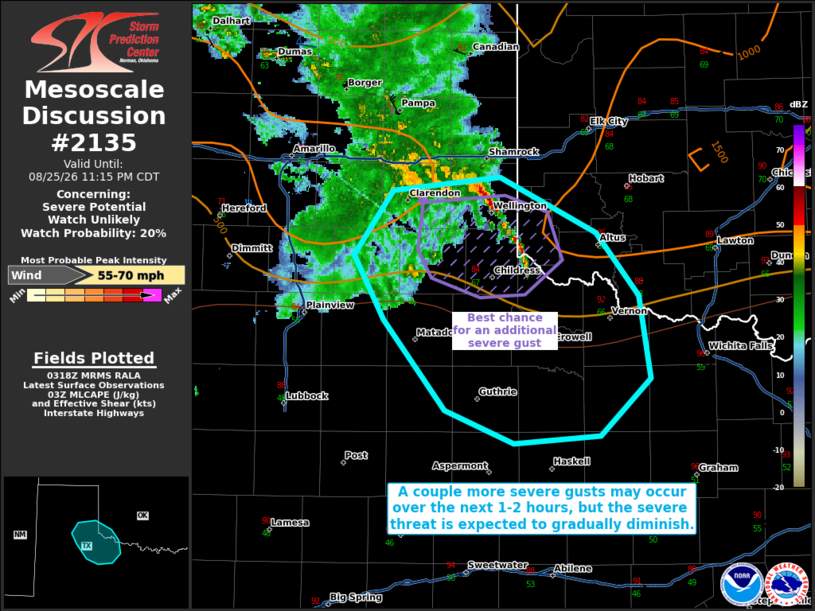
   SUMMARY...A couple more severe gusts cannot be ruled out over the
   next hour or so. However, the severe threat appears to be
   diminishing and this trend should continue through tonight. A
   downstream WW issuance is not expected.

   DISCUSSION...A cold-pool-driven MCS with a history of numerous
   measured severe gusts appears to have progressed through the
   majority of its lifecycle, and is showing gradual weakening trends.
   A rapidly propagating cold pool is still evident, so until the
   boundary layer can meaningfully decouple further, a couple of 50+ kt
   gusts still cannot be ruled out. Still, the decaying MCS is also
   progressing toward a lesser sheared/buoyant airmass, so the
   weakening severe trend should continue. A downstream Severe
   Thunderstorm Watch issuance is not anticipated.

   ..Squitieri/Thompson.. 08/26/2026

   ...Please see www.spc.noaa.gov for graphic product...

   ATTN...WFO...OUN...SJT...LUB...AMA...

   LAT...LON   34570131 35000099 35080014 34719937 34309903 33759893
               33369933 33320003 33540057 34130107 34570131

   MOST PROBABLE PEAK WIND GUST...55-70 MPH
|
|
|
Top/All Mesoscale Discussions/Forecast Products/Home |
|
Source link