

| Mesoscale Discussion 2129 | |
| < Previous MD Next MD > | |

|
|
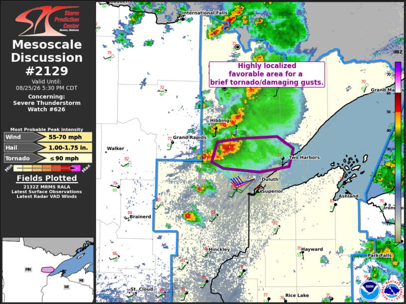
Mesoscale Discussion 2129 NWS Storm Prediction Center Norman OK 0433 PM CDT Tue Aug 25 2026 Areas affected...Parts of northeastern Minnesota Concerning...Severe Thunderstorm Watch 626... Valid 252133Z - 252230Z The severe weather threat for Severe Thunderstorm Watch 626 continues. SUMMARY...A highly localized favorable corridor for supercell intensification and a brief tornado and damaging wind gusts may persist for another hour or so. DISCUSSION...A weak, semi-discrete supercell structure is tracking eastward across parts of northeastern MN, with access to warm/unstable inflow to its southeast. Trailing cells and associated outflow are approaching this storm from the west. This could support a constructive cell interaction and brief intensification of the supercell as it continues eastward for the next 30 min to an hour -- before being undercut by the outflow. This could support a locally favorable risk for a brief tornado and damaging wind gusts. ..Weinman.. 08/25/2026 ...Please see www.spc.noaa.gov for graphic product... ATTN...WFO...DLH... LAT...LON 46909212 46939270 47019289 47229279 47279241 47299184 47169157 46969164 46909212 MOST PROBABLE PEAK TORNADO INTENSITY...UP TO 90 MPH MOST PROBABLE PEAK WIND GUST...55-70 MPH MOST PROBABLE PEAK HAIL SIZE...1.00-1.75 IN |
|
|
Top/All Mesoscale Discussions/Forecast Products/Home |
|
Source link