

| Mesoscale Discussion 2128 | |
| < Previous MD | |
|
|
   Mesoscale Discussion 2128
   NWS Storm Prediction Center Norman OK
   0353 PM CDT Tue Aug 25 2026

   Areas affected...southeastern Wyoming...northeastern
   Colorado...western Nebraska

   Concerning...Severe potential...Watch possible

   Valid 252053Z - 252300Z

   Probability of Watch Issuance...60 percent

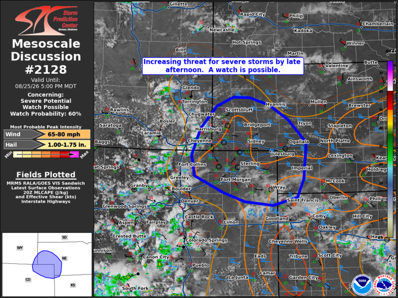
   SUMMARY...Increasing threat for severe storms by late afternoon. A
   watch is possible.

   DISCUSSION...Easterly upslope flow across western NE/KS into eastern
   Colorado to the foothills is contributing to steadily increasing
   moisture into eastern Colorado/southeastern Wyoming. Recent ACARS
   soundings from DEN show MLCIN remains. MLCAPE around 1000-2000 J/kg
   is noted within SPC Mesoanalysis from eastern Colorado into western
   Nebraska/northern Kansas. Convection has increased along the high
   terrain.

   Guidance suggests that with further heating and forcing for ascent
   with an upstream disturbance shifting eastward late this
   afternoon/early evening, thunderstorms will increase in coverage
   spread into the lower plains in eastern Colorado and eventually into
   portions of the central Plains. With modest westerly flow aloft and
   deep layer shear around 30-35 kts, supercell modes will be favored
   initially. Large hail and severe gusts will be the primary threat,
   given steep low to mid-level lapse rates and aforementioned
   thermodynamic environment. A transition to clusters and upscale
   growth though the evening with severe gusts becoming the primary
   threat through the evening. A watch will be possible this evening to
   cover this potential.

   ..Thornton/Smith.. 08/25/2026

   ...Please see www.spc.noaa.gov for graphic product...

   ATTN...WFO...LBF...GLD...BOU...CYS...

   LAT...LON   40880465 41510439 42020391 42230340 42220289 42060228
               41710169 41170115 40340124 39910145 39720219 39820303
               40030369 40410456 40880465

   MOST PROBABLE PEAK WIND GUST...65-80 MPH
   MOST PROBABLE PEAK HAIL SIZE...1.00-1.75 IN
|
|
|
Top/All Mesoscale Discussions/Forecast Products/Home |
|
Source link