

| Mesoscale Discussion 2120 | |
| < Previous MD | |
|
|
   Mesoscale Discussion 2120
   NWS Storm Prediction Center Norman OK
   0529 PM CDT Mon Aug 24 2026

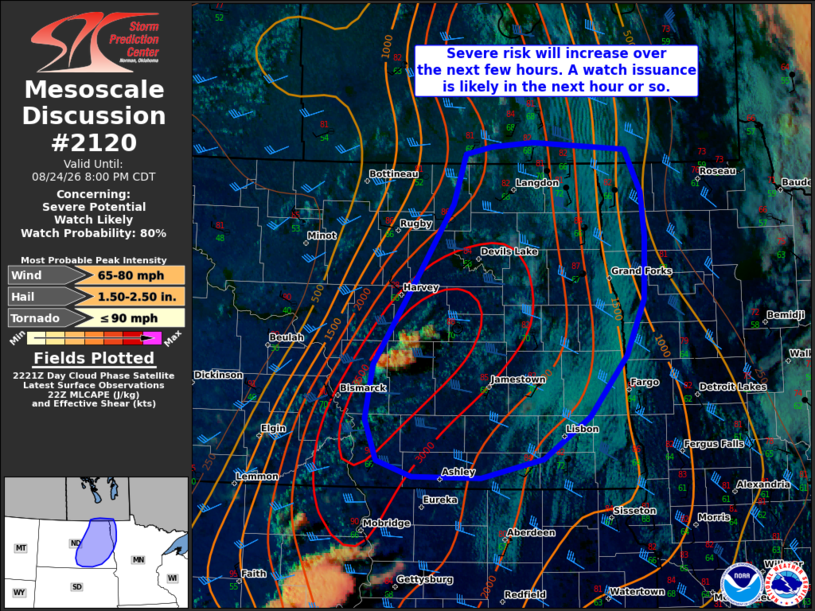
   Areas affected...Parts of eastern North Dakota and northwestern
   Minnesota

   Concerning...Severe potential...Watch likely

   Valid 242229Z - 250100Z

   Probability of Watch Issuance...80 percent

   SUMMARY...The severe risk will increase from west to east over the
   next few hours. The primary concerns will be large to very large
   hail and severe wind gusts. A watch will likely be needed in the
   next hour or so.

   DISCUSSION...The latest Day Cloud Phase satellite imagery indicates
   deepening boundary-layer cumulus along a surface front/wind shift in
   parts of central ND -- immediately east-northeast of Bismarck. In
   the near term, isolated convective initiation will be possible along
   the wind shift, as earlier capping at the base of the EML (sampled
   by the BIS 18Z sounding) continues to erode amid an increasingly
   warm/unstable PBL. Steep midlevel lapse rates atop the warm/moist
   PBL and an elongating/mostly straight holograph (around 40-50 kt of
   effective shear) will conditionally support discrete supercells
   capable of producing large to very large hail and locally severe
   wind gusts. However, weak large-scale forcing for ascent limits
   confidence in both the coverage and evolution of this initial storm
   development.

   Over the next few hours, increasing ascent accompanying a midlevel
   wave to the north should support an increase in storm coverage along
   the surface front. The aforementioned environment will promote an
   increasing risk of scattered supercells capable of producing large
   hail and severe wind gusts. With time and eastward extent, upscale
   growth into organized clusters could pose an increasing risk of
   severe wind. A watch will likely be needed in the next hour or so.

   ..Weinman/Thompson.. 08/24/2026

   ...Please see www.spc.noaa.gov for graphic product...

   ATTN...WFO...FGF...BIS...

   LAT...LON   46190025 46590041 47090031 47979967 48629920 49099903
               49169866 49209809 49129680 48739658 48309653 47729655
               47199679 46629730 46229794 46039880 46049976 46190025

   MOST PROBABLE PEAK TORNADO INTENSITY...UP TO 90 MPH
   MOST PROBABLE PEAK WIND GUST...65-80 MPH
   MOST PROBABLE PEAK HAIL SIZE...1.50-2.50 IN
|
|
|
Top/All Mesoscale Discussions/Forecast Products/Home |
|
Source link