

| Mesoscale Discussion 2115 | |
| < Previous MD | |
|
|
   Mesoscale Discussion 2115
   NWS Storm Prediction Center Norman OK
   0203 PM CDT Mon Aug 24 2026

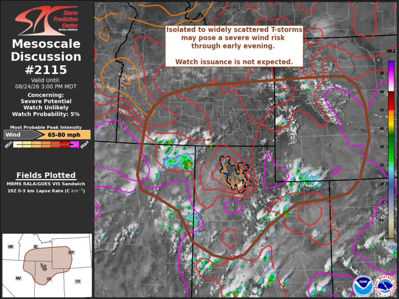
   Areas affected...Portions of the Great Basin

   Concerning...Severe potential...Watch unlikely

   Valid 241903Z - 242100Z

   Probability of Watch Issuance...5 percent

   SUMMARY...Isolated to widely-scattered thunderstorms are expected to
   overspread much of the northern Great Basin through early evening.
   The more intense thunderstorms will be capable of severe downburst
   winds. However, the overall threat should remain transient/isolated
   enough to preclude watch issuance.

   DISCUSSION...Over the past hour, GOES imagery has shown a steady
   uptick in coverage and depth of convective cumulus across the
   central and northern Great Basin. This comes as temperatures warm
   into the mid 80s to low 90s and lingering inhibition is eroded.
   Based on recent surface observations and the recent 18z LKN
   sounding, MLCAPE values generally between 250-500 J/kg are likely
   overspreading much of the region, and low-level lapse rates are
   approaching dry adiabatic with LCLs estimated to be near 2 to 2.5
   km. Although buoyancy magnitudes are generally fairly modest, the
   dry and deeply-mixed boundary layer is favorable for accelerating
   downdrafts - especially with the deeper convective cores that can be
   influenced by 30-35 knot mid-level flow above 6 km as sampled by the
   LKN sounding (which may promote some degree of storm longevity and
   organization). In general, thunderstorm coverage and longevity is
   expected to remain fairly limited given weak large-scale forcing for
   ascent, modest buoyancy, and somewhat weak deep-layer wind shear,
   but latest CAM ensemble guidance suggests gusts up to 60-75 mph will
   be possible with the more intense downbursts.

   ..Moore/Smith.. 08/24/2026

   ...Please see www.spc.noaa.gov for graphic product...

   ATTN...WFO...CYS...RIW...GJT...SLC...PIH...BOI...LKN...

   LAT...LON   40630834 40500897 40381024 39741131 38961216 38821264
               38911328 39281405 40141461 40521545 40701599 41111617
               42651593 43031566 43351522 43511471 43681382 43930885
               43890833 43650787 43030756 42150747 40990791 40630834

   MOST PROBABLE PEAK WIND GUST...65-80 MPH
|
|
|
Top/All Mesoscale Discussions/Forecast Products/Home |
|
Source link