

| Mesoscale Discussion 2112 | |
| < Previous MD | |

|
|
   Mesoscale Discussion 2112
   NWS Storm Prediction Center Norman OK
   1029 AM CDT Mon Aug 24 2026

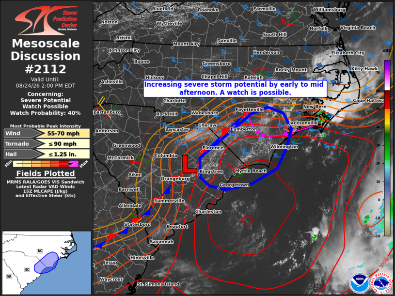
   Areas affected...portions of eastern North Carolina into the Pee Dee
   region of South Carolina

   Concerning...Severe potential...Watch possible

   Valid 241529Z - 241800Z

   Probability of Watch Issuance...40 percent

   SUMMARY...The threat for at least isolated severe weather is
   expected to increase by early to mid afternoon. Convective trends
   are being monitored for a possible severe thunderstorm watch.

   DISCUSSION...Mid-morning mesoanalysis indicates a weak surface low
   between Sumter and Florence, SC along a quasi-stationary surface
   boundary extending along the Carolina coastal plain. Ahead of the
   front, the 12Z Charleston, SC and Newport, NC soundings sampled a
   very moist boundary layer with dewpoints in the mid to upper 70s,
   which yielded a strongly unstable environment with MLCAPE of
   3000-4000 J/kg.

   Visible satellite imagery indicates deepening cumulus along the
   developing sea breeze near the SC-NC border, which will likely
   evolve into thunderstorms over the next couple of hours with
   continued heating and destabilization of the boundary layer.
   Additional storms are possible farther inland ahead of the surface
   low and along the synoptic front. However, latest CAM guidance
   suggests the greatest storm coverage along the sea breeze and
   trailing outflow boundary from storms moving toward the NC Outer
   Banks.

   The region resides within the southern fringe of stronger
   mid/upper-level winds attendant to troughing over the Northeast with
   around 30 kt of deep-layer shear present across the narrow warm
   sector. As such, the potential exists for some storm organization,
   including periodic supercell structures with an associated risk for
   damaging wind gusts and perhaps marginally severe hail. A brief
   tornado risk may also materialize given a supercell storm mode along
   the existing boundaries.

   The potentially limited geographic extent of the threat area leads
   to uncertainty in a severe thunderstorm watch issuance.

   ..Mead/Smith.. 08/24/2026

   ...Please see www.spc.noaa.gov for graphic product...

   ATTN...WFO...MHX...RAH...ILM...

   LAT...LON   33417952 33617977 34037979 34567908 34807873 35027842
               35177797 35047756 34687733 34217750 33807774 33467842
               33337909 33417952

   MOST PROBABLE PEAK TORNADO INTENSITY...UP TO 90 MPH
   MOST PROBABLE PEAK WIND GUST...55-70 MPH
   MOST PROBABLE PEAK HAIL SIZE...UP TO 1.25 IN
|
|
|
Top/All Mesoscale Discussions/Forecast Products/Home |
|
Source link