

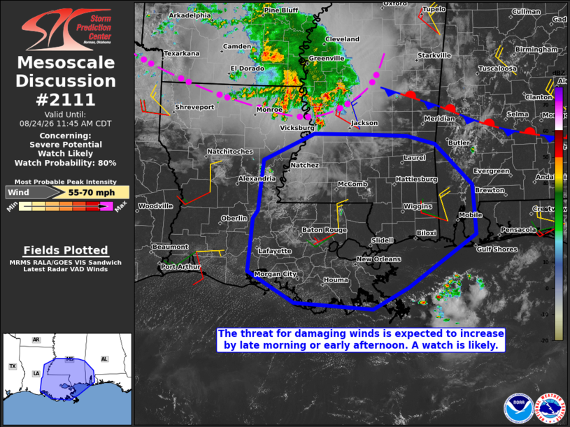
| Mesoscale Discussion 2111 | |
| < Previous MD | |

|
|
   Mesoscale Discussion 2111
   NWS Storm Prediction Center Norman OK
   0912 AM CDT Mon Aug 24 2026

   Areas affected...southern Mississippi...east-central and southeast
   Louisiana...and far southwest Alabama

   Concerning...Severe potential...Watch likely

   Valid 241412Z - 241645Z

   Probability of Watch Issuance...80 percent

   SUMMARY...The threat for damaging winds with gusts up to 60-65 mph
   is expected to increase by late morning into early afternoon. A
   severe thunderstorm watch will be required by 16Z or 17z.

   DISCUSSION...Recent trends in volumetric radar and IR satellite data
   indicate at least a temporary deepening of convective updrafts from
   west through north of Yazoo City, along the leading edge of an
   elongated MCS that extends into central AR. The 12Z Jackson, MS and
   Slidell, LA soundings sampled the presence of a very moist inflow
   air mass, characterized by boundary-layer dewpoints in the mid to
   upper 70s, yielding MUCAPE of 3000-4000 J/kg. That instability will
   fuel a gradual increase in storm coverage and intensity through the
   remainder of the morning along and slightly ahead of the system cold
   pool as temperatures warm and low-level lapse rates steepen. The
   instability in conjunction with some enhancement of northwest winds
   above 3 km AGL per the current Little Rock, AR and Memphis, TN VWPs
   will support the development of a potentially intense cold pool with
   some explicit CAM wind gust data indicating wind gusts up to 60-65
   mph.

   ..Mead/Smith.. 08/24/2026

   ...Please see www.spc.noaa.gov for graphic product...

   ATTN...WFO...MOB...JAN...LIX...LCH...

   LAT...LON   30869201 31729190 32189089 32188981 32158901 32018847
               31298773 30458766 29538901 29168972 29289127 29809219
               30719211 30869201

   MOST PROBABLE PEAK WIND GUST...55-70 MPH
|
|
|
Top/All Mesoscale Discussions/Forecast Products/Home |
|
Source link