

| Mesoscale Discussion 2087 | |
| < Previous MD | |

|
|
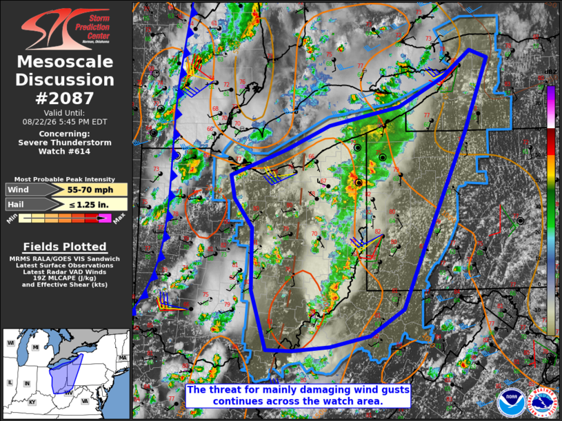
Mesoscale Discussion 2087 NWS Storm Prediction Center Norman OK 0250 PM CDT Sat Aug 22 2026 Areas affected...central and eastern Ohio into northern West Virginia and western parts of New York and Pennsylvania Concerning...Severe Thunderstorm Watch 614... Valid 221950Z - 222145Z The severe weather threat for Severe Thunderstorm Watch 614 continues. SUMMARY...The threat for mainly damaging wind gusts is expected to continue across the watch area late this afternoon into evening. DISCUSSION...Multiple bands of strong to severe thunderstorms are ongoing within low-level confluence zones preceding the synoptic cold front. As of 1945Z, the most intense convection was located over far eastern OH, where several instances of wind damage have been reported. Latest mesoanalysis indicates a plume of steep low-level lapse rates in excess of 8 C/km has developed ahead of that convective band, which should allow the damaging wind threat to spread into western PA over the next hour. Regional VWPs indicate generally weak low-level winds with pockets of around 30 kt of deep-layer shear, which may be supportive of more organized bowing/line segments capable of a comparatively greater damaging wind threat. Otherwise, expect storms to remain somewhat disorganized and shorter lived, but still capable of locally damaging wind gusts. ..Mead.. 08/22/2026 ...Please see www.spc.noaa.gov for graphic product... ATTN...WFO...BUF...CTP...PBZ...RLX...CLE...ILN... LAT...LON 39718266 40618267 41028300 41368307 41738204 42088121 42347989 42767905 43157852 43047819 41977864 40357942 39447982 39078044 38908120 38848189 38858239 39718266 MOST PROBABLE PEAK WIND GUST...55-70 MPH MOST PROBABLE PEAK HAIL SIZE...UP TO 1.25 IN |
|
|
Top/All Mesoscale Discussions/Forecast Products/Home |
|
Source link