

| Mesoscale Discussion 2064 | |
| < Previous MD | |

|
|
   Mesoscale Discussion 2064
   NWS Storm Prediction Center Norman OK
   1118 PM CDT Thu Aug 20 2026

   Areas affected...portions of northwestern Kansas

   Concerning...Severe potential...Watch unlikely

   Valid 210418Z - 210515Z

   Probability of Watch Issuance...5 percent

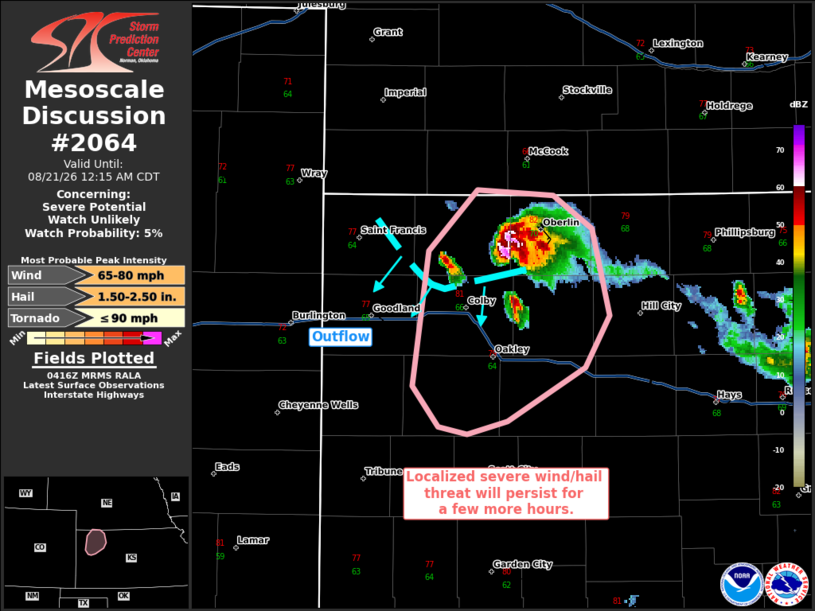
   SUMMARY...Severe wind and hail (some significant) remains a concern
   for a few more hours with an ongoing mature supercell.

   DISCUSSION...A relatively long-lived supercell continues to track
   south-southwest, with a history of 2+ inch diameter hail and 75+ mph
   measured gusts. Furthermore, MRMS MESH also indicates hail over 2
   inches in diameter may be falling with this storm. This supercell is
   likely benefiting from locally higher buoyancy (i.e. 2000 J/kg
   MLCAPE) and 50+ kts of effective bulk shear. Nonetheless, MLCINH
   will continue to increase through the evening, likely resulting in a
   gradual weakening with time. Until this occurs though, a localized
   severe threat should persist.

   ..Squitieri/Guyer.. 08/21/2026

   ...Please see www.spc.noaa.gov for graphic product...

   ATTN...WFO...GLD...

   LAT...LON   39690130 40030097 40000043 39820017 39340004 39060022
               38780076 38700103 38750124 38970142 39690130

   MOST PROBABLE PEAK TORNADO INTENSITY...UP TO 90 MPH
   MOST PROBABLE PEAK WIND GUST...65-80 MPH
   MOST PROBABLE PEAK HAIL SIZE...1.50-2.50 IN
|
|
|
Top/All Mesoscale Discussions/Forecast Products/Home |
|
Source link