

| Mesoscale Discussion 2061 | |
| < Previous MD | |
|
|
   Mesoscale Discussion 2061
   NWS Storm Prediction Center Norman OK
   0728 PM CDT Thu Aug 20 2026

   Areas affected...portions of central Nebraska into far northwestern
   Kansas

   Concerning...Severe potential...Watch unlikely

   Valid 210028Z - 210200Z

   Probability of Watch Issuance...20 percent

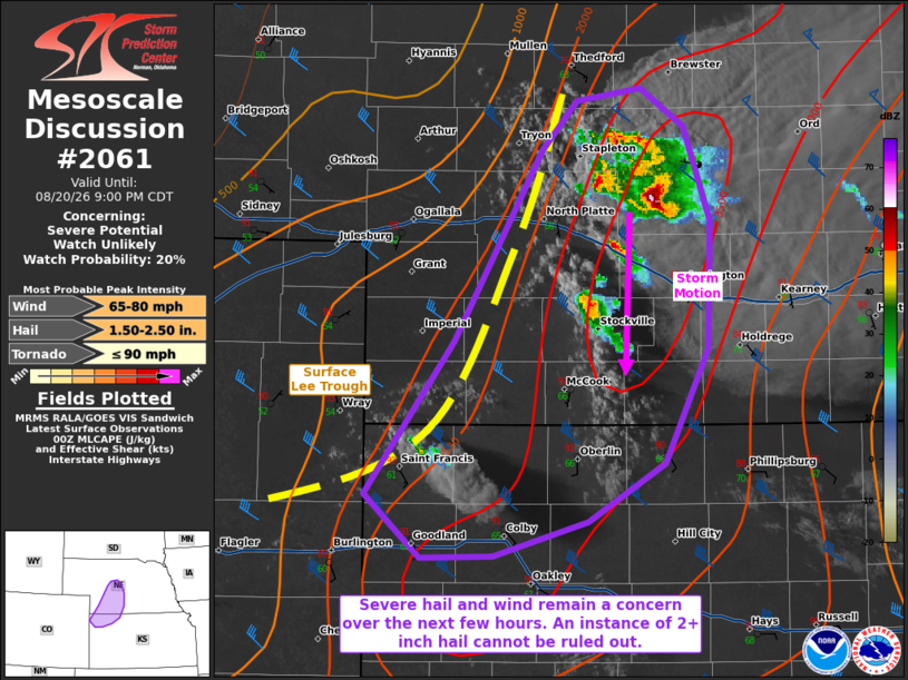
   SUMMARY...Isolated severe hail and wind may accompany the stronger
   storms this evening. An instance of 2+ inch diameter hail is
   possible with any longer-lasting, discrete supercells.

   DISCUSSION...A long-lived thunderstorm cluster with transient
   supercell characteristics and a history of producing severe gusts
   continues to propagate southward along/ahead of a surface trough,
   where MLCINH is minimal. Latest MRMS MESH depicts a potential
   increase in hail size with an embedded supercell structure.
   Furthermore, additional storms also initiating ahead of the surface
   trough, along a confluence zone in southwestn NE into far northwest
   KS. In this region, 3000+ J/kg MLCAPE is in place, along with at
   least 40 kts of effective bulk shear per 00Z mesoanalysis. The
   latest GLD shows an elongated hodograph, indicative of splitting
   supercell structures with a continued severe hail/gust threat. When
   also considering 7-8 C/km mid-level lapse rates in place (per
   regional 00Z observed soundings), an instance of 2+ inch diameter
   hail cannot be ruled out with mature supercells at their peak
   intensity.

   ..Squitieri/Guyer.. 08/21/2026

   ...Please see www.spc.noaa.gov for graphic product...

   ATTN...WFO...GID...LBF...GLD...

   LAT...LON   39620205 40460141 41500077 41780052 41840007 41649975
               41129957 40419958 39799990 39470044 39280113 39260165
               39620205

   MOST PROBABLE PEAK TORNADO INTENSITY...UP TO 90 MPH
   MOST PROBABLE PEAK WIND GUST...65-80 MPH
   MOST PROBABLE PEAK HAIL SIZE...1.50-2.50 IN
|
|
|
Top/All Mesoscale Discussions/Forecast Products/Home |
|
Source link