

| Mesoscale Discussion 2058 | |
| < Previous MD | |
|
|
   Mesoscale Discussion 2058
   NWS Storm Prediction Center Norman OK
   0607 PM CDT Thu Aug 20 2026

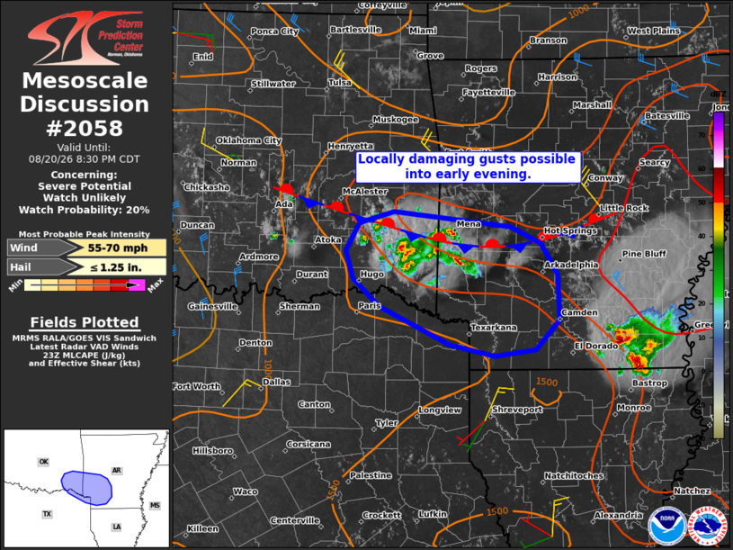
   Areas affected...Parts of southeast OK...southwest AR...and far
   northeast TX

   Concerning...Severe potential...Watch unlikely

   Valid 202307Z - 210130Z

   Probability of Watch Issuance...20 percent

   SUMMARY...Thunderstorms will be capable of producing strong to
   locally damaging wind gusts for the next few hours. A watch is not
   currently expected, though convective trends are being monitored.

   DISCUSSION...Thunderstorms are increasing in coverage along a
   stationary boundary draped across southeast OK and southwest AR.
   Along/south of the boundary, temperatures have warmed to near 105 F
   amid lower/middle 60s dewpoints -- resulting in a strongly unstable
   air mass. This activity is largely displaced from a midlevel trough
   and enhanced flow aloft moving across the lower OH Valley, which
   should tend to reduce overall convective organization. Nevertheless,
   around 25 kt of midlevel northwesterly flow oriented perpendicular
   to the stationary boundary and evolving cluster of storms could
   support a loosely organized cluster capable of producing locally
   damaging wind gusts for the next few hours.

   ..Weinman/Guyer.. 08/20/2026

   ...Please see www.spc.noaa.gov for graphic product...

   ATTN...WFO...LZK...SHV...TSA...FWD...

   LAT...LON   33729526 34039560 34349570 34669553 34799505 34629348
               34429306 34089284 33579283 33249314 33179369 33299431
               33729526

   MOST PROBABLE PEAK WIND GUST...55-70 MPH
   MOST PROBABLE PEAK HAIL SIZE...UP TO 1.25 IN
|
|
|
Top/All Mesoscale Discussions/Forecast Products/Home |
|
Source link