

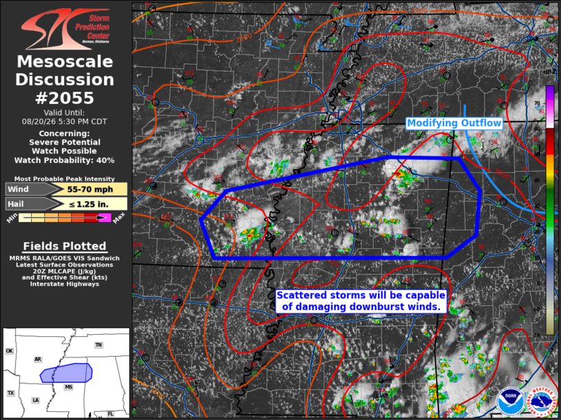
| Mesoscale Discussion 2055 | |
| < Previous MD | |

|
|
   Mesoscale Discussion 2055
   NWS Storm Prediction Center Norman OK
   0333 PM CDT Thu Aug 20 2026

   Areas affected...Southeast Arkansas into northern Mississippi and
   northern Alabama

   Concerning...Severe potential...Watch possible

   Valid 202033Z - 202230Z

   Probability of Watch Issuance...40 percent

   SUMMARY...Scattered storms will be capable of primarily damaging
   downburst winds and perhaps isolated large hail. A watch is possible
   depending on convective trends over the next couple of hours.

   DISCUSSION...Scattered thunderstorms are in the process of
   developing within parts of the Mid-South into the Southeast. The
   highest coverage of storms will likely occur ahead of a weak
   perturbation in southern Arkansas and where temperatures have
   reached the upper 90s F. Rich surface moisture/large PWAT values and
   steeper than typical mid-level lapse rates will support a threat for
   damaging downburst winds and perhaps isolated large hail. A greater
   localized wind threat may emerge as storm outflows congeal amid a
   weakly sheared environment. Cooler air is evident farther east where
   outflow continues to modify. Storm coverage there is less certain. A
   watch is possible for portions of these regions depending on
   convective trends the remainder of this afternoon.

   ..Wendt/Smith.. 08/20/2026

   ...Please see www.spc.noaa.gov for graphic product...

   ATTN...WFO...BMX...HUN...MEG...JAN...LZK...

   LAT...LON   33139204 33659228 34059186 34538920 34508803 34068768
               33448777 33148825 33139204

   MOST PROBABLE PEAK WIND GUST...55-70 MPH
   MOST PROBABLE PEAK HAIL SIZE...UP TO 1.25 IN
|
|
|
Top/All Mesoscale Discussions/Forecast Products/Home |
|
Source link