

| Mesoscale Discussion 2054 | |
| < Previous MD Next MD > | |
|
|
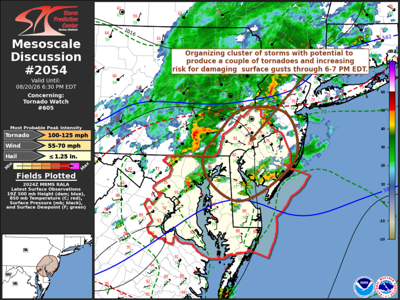
Mesoscale Discussion 2054 NWS Storm Prediction Center Norman OK 0326 PM CDT Thu Aug 20 2026 Areas affected...parts of southeastern Pennsylvania...southern New Jersey...eastern Maryland and Delaware Concerning...Tornado Watch 605... Valid 202026Z - 202230Z The severe weather threat for Tornado Watch 605 continues. SUMMARY...An organizing cluster of storms will pose increasing potential to produce damaging wind gusts and a couple of tornadoes into and across the Greater Philadelphia vicinity through the the 6-7 PM EDT time frame. DISCUSSION...A more prominent, but still compact, clustering of intensifying thunderstorm development is ongoing south/southeast of Harrisburg PA. This does appear focused near a weak developing frontal wave, and is perhaps being supported by forcing for ascent downstream of an east-northeastward propagating 50+ kt mid-level jet streak, based on the latest Rapid Refresh output. Strongest recent boundary-layer destabilization, associated with insolation and thermal/moisture advection, has become focused to the north of the Greater Baltimore area the past few hours. Updraft inflow emanating from this environment, probably will support further upscale growth and intensification of the convective system into and across the Greater Philadelphia area through 22-23Z. This may include evolving supercell structures posing a risk for tornadoes, and increasing risk for strong to severe surface gusts. ..Kerr.. 08/20/2026 ...Please see www.spc.noaa.gov for graphic product... ATTN...WFO...PHI...CTP...LWX... LAT...LON 40137604 40567548 40477448 39757423 39187484 38917557 39187615 39667641 40137604 MOST PROBABLE PEAK TORNADO INTENSITY...100-125 MPH MOST PROBABLE PEAK WIND GUST...55-70 MPH MOST PROBABLE PEAK HAIL SIZE...UP TO 1.25 IN |
|
|
Top/All Mesoscale Discussions/Forecast Products/Home |
|
Source link