

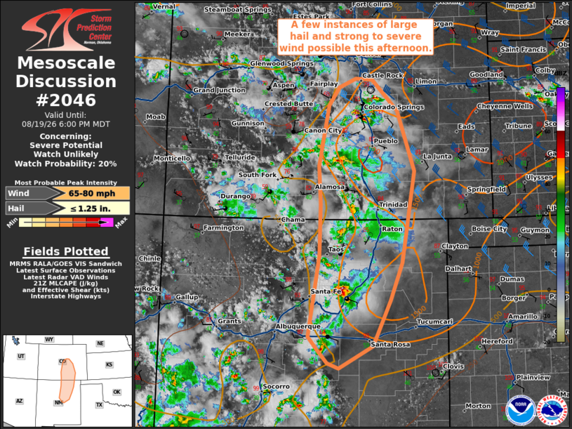
| Mesoscale Discussion 2046 | |
| < Previous MD | |

|
|
   Mesoscale Discussion 2046
   NWS Storm Prediction Center Norman OK
   0459 PM CDT Wed Aug 19 2026

   Areas affected...eastern New Mexico...eastern Colorado

   Concerning...Severe potential...Watch unlikely

   Valid 192159Z - 200000Z

   Probability of Watch Issuance...20 percent

   SUMMARY...A few instances of large hail and damaging wind will be
   possible this afternoon.

   DISCUSSION...Thunderstorm activity has increased in coverage along
   the high terrain across eastern New Mexico and eastern Colorado this
   afternoon. This activity will slowly spread into the lower plains
   through the afternoon and evening.

   Deep layer shear for organization is best across eastern Colorado,
   with weaker shear across eastern New Mexico. The most favorable
   instability also resides across eastern Colorado. A few isolated
   supercells with large hail will be possible initially. Large dew
   point depressions and steep low level lapse rates will likely lead
   to outflow dominate storms and more of a threat for strong to severe
   wind. Overall, this threat should remain too localized for watch
   issuance.

   ..Thornton/Guyer.. 08/19/2026

   ...Please see www.spc.noaa.gov for graphic product...

   ATTN...WFO...PUB...BOU...ABQ...

   LAT...LON   36370573 37240570 37910574 38940554 39250532 39390496
               39380460 38850406 37810371 36260398 35610422 34830460
               34460531 34540555 34790578 35000596 36370573

   MOST PROBABLE PEAK WIND GUST...65-80 MPH
   MOST PROBABLE PEAK HAIL SIZE...UP TO 1.25 IN
|
|
|
Top/All Mesoscale Discussions/Forecast Products/Home |
|
Source link