

| Mesoscale Discussion 2041 | |
| < Previous MD | |
|
|
   Mesoscale Discussion 2041
   NWS Storm Prediction Center Norman OK
   0230 PM CDT Wed Aug 19 2026

   Areas affected...Northwestern Missouri into far northeast Kansas

   Concerning...Severe potential...Watch likely

   Valid 191930Z - 192100Z

   Probability of Watch Issuance...80 percent

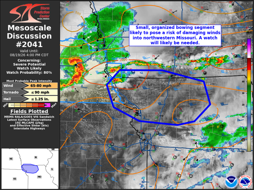
   SUMMARY...Continued eastward progress of an organized bowing segment
   and potential supercells ahead of the linear convection will pose a
   threat for severe wind gusts, isolated large hail, and possibly a
   brief tornado. A watch is likely this afternoon.

   DISCUSSION...Ample surface heating has occurred in between areas of
   cloud cover in northern Missouri and adjacent northeast Kansas and
   far southern Iowa. In southeastern Nebraska a small bowing segment
   with a history of wind damage and measured severe wind gusts will
   generally move into this relatively more favorable zone. Effective
   shear of 45-50 kt will continue to promote storm organization. As
   the bowing segment takes a more easterly track into more buoyant
   air, the line will be more orthogonal to the deep-layer shear.
   Additionally, a supercell or two is evident near the Missouri river.
   These storms would be capable of large hail and perhaps a brief
   tornado. A watch will likely be needed.

   ..Wendt/Smith.. 08/19/2026

   ...Please see www.spc.noaa.gov for graphic product...

   ATTN...WFO...DMX...EAX...OAX...TOP...

   LAT...LON   39599484 39909559 40409581 40759542 40759415 40499294
               39969276 39589322 39509373 39599484

   MOST PROBABLE PEAK TORNADO INTENSITY...UP TO 90 MPH
   MOST PROBABLE PEAK WIND GUST...65-80 MPH
   MOST PROBABLE PEAK HAIL SIZE...UP TO 1.25 IN
|
|
|
Top/All Mesoscale Discussions/Forecast Products/Home |
|
Source link