

| Mesoscale Discussion 2035 | |
| < Previous MD | |

|
|
   Mesoscale Discussion 2035
   NWS Storm Prediction Center Norman OK
   0122 AM CDT Wed Aug 19 2026

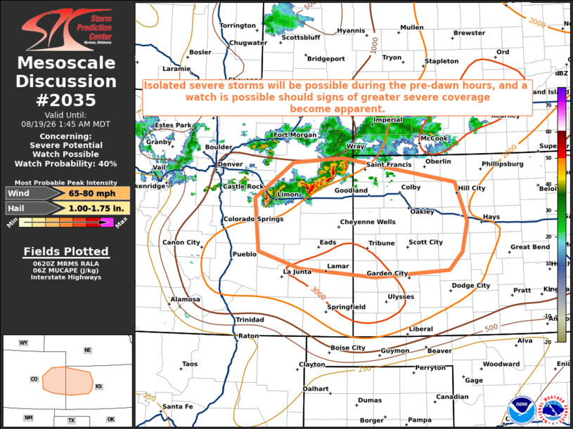
   Areas affected...Northeast and east-central Colorado...western
   Kansas

   Concerning...Severe potential...Watch possible

   Valid 190622Z - 190745Z

   Probability of Watch Issuance...40 percent

   SUMMARY...Isolated strong to severe storms will be possible during
   the early morning hours posing a risk for damaging gusts and severe
   hail. Convective trends will be monitored and a watch is possible
   should signs of sufficient severe storm coverage become clearer.

   DISCUSSION...Scattered clusters of strong, occasionally severe,
   storms were in progress across northeast CO at 0615z with a report
   of 64 mph at Akron. These storms were located within a seasonably
   strong belt of west-northwesterly mid-level flow and around 40 kts
   of westerly effective shear. The downstream thermodynamic
   environment becomes progressively more unstable with eastward extent
   with MUCAPE averaging 2000 J/kg, locally higher, across western KS.

   Latest short-range guidance suggests these elevated clusters of
   storms will continue moving southeast into western KS during the
   pre-dawn hours with isolated instances of strong/severe gusts and
   hail possible.  It remains unclear whether the severe storm coverage
   would warrant a Severe Thunderstorm Watch, however convective trends
   will continue to be monitored, and a watch is possible should
   short-term trends suggest more than isolated coverage.

   ..Bunting/Mosier.. 08/19/2026

   ...Please see www.spc.noaa.gov for graphic product...

   ATTN...WFO...DDC...GLD...PUB...BOU...

   LAT...LON   39870331 39960228 39559988 38899962 38389973 38080001
               37970158 38110317 38400404 39270413 39870331

   MOST PROBABLE PEAK WIND GUST...65-80 MPH
   MOST PROBABLE PEAK HAIL SIZE...1.00-1.75 IN
|
|
|
Top/All Mesoscale Discussions/Forecast Products/Home |
|
Source link