

| Mesoscale Discussion 2033 | |
| < Previous MD | |
|
|
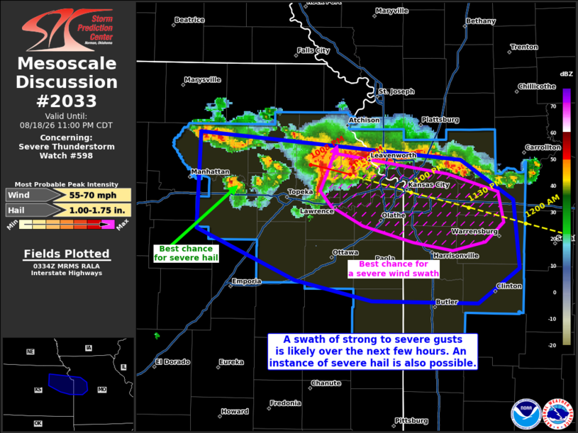
Mesoscale Discussion 2033 NWS Storm Prediction Center Norman OK 1037 PM CDT Tue Aug 18 2026 Areas affected...portions of northeastern Kansas into western Missouri Concerning...Severe Thunderstorm Watch 598... Valid 190337Z - 190400Z The severe weather threat for Severe Thunderstorm Watch 598 continues. SUMMARY...A swath of damaging to occasionally severe gusts is becoming increasingly likely along the KS/MO border, including the Kansas City Metropolitan area. A few nearby supercell structures may also pose an occasional risk for severe hail. DISCUSSION...An MCS is organizing over northeastern KS, with KEAX reflectivity and velocity data depicting the potential for hydrometeor loading given large merging cores. As a result, several severe gusts have been observed over the last 30 minutes. The current thinking is that appreciable outflow with these storms will yield a damaging to occasionally severe wind swath along the KS/MO border despite the decoupled boundary layer in place. These storms will pass over the Kansas City Metropolitan area over the next hour or so, accompanied by gusts occasionally exceeding 60 mph. Transient supercells are also flanking this MCS to the southwest with deeper cores, which may favor a few instances of severe hail as well. ..Squitieri.. 08/19/2026 ...Please see www.spc.noaa.gov for graphic product... ATTN...WFO...EAX...TOP... LAT...LON 39519646 39309408 39019360 38529354 38289392 38299489 38449560 38829650 39519646 MOST PROBABLE PEAK WIND GUST...55-70 MPH MOST PROBABLE PEAK HAIL SIZE...1.00-1.75 IN |
|
|
Top/All Mesoscale Discussions/Forecast Products/Home |
|
Source link